Paparoa National Park
Located in the West Coast region
|
Introduction
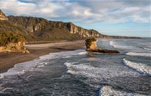
Luxuriant coastal forest, limestone cliffs and canyons, caves and underground streams, and an absolutely spectacular coastline, are all packed into one national park. The bizarre ‘pancake-stack’ coastal formations attract visitors to the area.Find things to do and places to stay Paparoa National Park
Paparoa National Park offers caving for beginners and experienced cavers. The Punakaiki Cavern, right beside SH6, is a safe introduction to a cave environment; all you need is a torch and good footwear.
Other cave systems within the park, like the Metro/Te Ananui require special entry permits and are accessible to the public only by guided parties. Contact the visitor centre for more details.
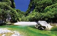
You can kayak and canoe on the Pororari River.
Paparoa National Park is located in the northern part of the South Island's West Coast. The park is located alongside the very scenic SH6, between the towns of Westport, 55 km to the north of Punakaiki, and Greymouth 43 km to the south.
Intercity buses have a regular service to the area. The nearest airport with scheduled flights is at Westport 55 km to the north.
There is no petrol station in Punakaiki, so remember to fuel up your vehicle in either Westport or Greymouth.
The climate at Paparoa National Park is basically temperate and in winter snow never reaches the lower portions of the park.
However, some tracks may involve river crossings so it is essential to check for the latest river conditions before starting your walk.
Much of the inland country within the park is wild and untracked, with the added danger of hidden holes and caverns. If you are going to be using the track system in the park for overnight trips make sure you are properly equipped and well prepared, and keep to the tracks.
Weather forecast
Check the weather and contact the visitor centre for the latest information on track conditions.
All drone use must be authorised by DOC
You must have a permit to fly a drone on public conservation land.
Established in 1987, Paparoa National Park is perhaps most famous for the Pancake Rocks and blowholes of Dolomite Point, near the little settlement of Punakaiki.
The Paparoa Range forms an impressive backdrop to the park; made of ancient granite which has been slowly shaped by ice into its present rugged outline.
Limestone underlies most of the park and it is responsible for the area's amazing landforms - high coastal cliffs, impressive river canyons, delicate cave formations and the bizarre ‘pancake-stack’ coastal formations that the area is so well known for.
The three blowholes at Dolomite Point put on their best performance during a south-westerly swell at high tide.
Vegetation within the park is wide and varied, due to the mild climate and high fertility. Near the coast, broadleaf forest dominates, with glades of exotic-looking nikau palms giving a subtropical feel. Large rata trees emerge above the forest canopy. Inland, the forest is made up of hard, red and silver beech, mixed with rimu and other podocarps.
Forest birds such as tui, bellbird/korimako and kereru/New Zealand pigeon migrate seasonally between coastal and upland forests.
The Westland petrel/titi colony south of the Punakaiki River is the only known place in the world where these burrowing seabirds breed. The birds live mostly out at sea, but during the breeding season you can see them flying to and from the colony at dusk and dawn.
The nocturnal and secretive great spotted kiwi/roroa is not often seen, but listen for a loud snuffling or a harsh whistling cry and you'll know one is close by.
Contacts
| Paparoa National Park Visitor Centre | |
|---|---|
| Phone | +64 3 731 1895 |
| paparoavc@doc.govt.nz | |
| Address | 4294 Coast Road Punakaiki RD 1 Runanga 7873 |
| Hours | Visitor centre hours and services |


