On 12 December 2025, the judicial review of decisions on the marine reserves was resolved by agreement between all participants and confirmed by the High Court.
This coastal region previously had no marine protected areas – as defined by New Zealand’s MPA Policy.
The marine reserves will protect important and unique coastal and estuarine habitats and the marine life within them. They contribute to New Zealand’s marine protection goals and international commitments to protect marine biodiversity.
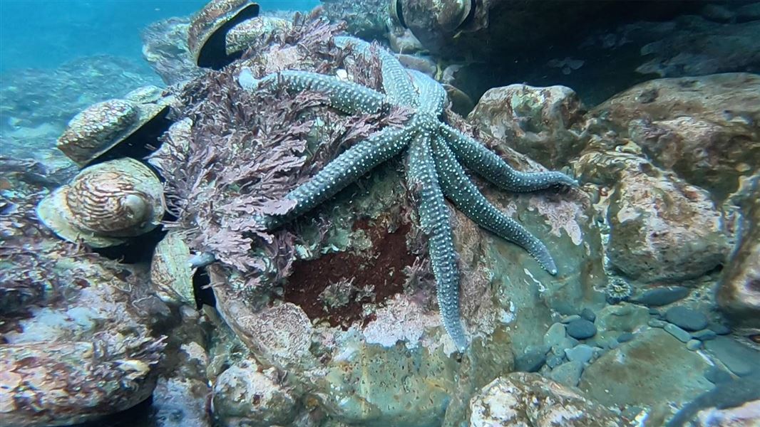
Habitats protected include estuarine and tidal lagoons, rocky reefs, offshore canyons, giant kelp forests, deep water bryozoan (lace coral) thickets and seagrass and red algae beds. These support an array of fish and other marine species.
Marine reserves provide the highest level of marine protection in New Zealand. Their main aim is to create an area that is free from human alteration to marine habitats and life, which provides a useful comparison for scientific study and allows ecosystems to recover to a more natural state.
Marine reserves are also special places where people can see rare and abundant sea life, and enjoy activities such as boating, snorkelling and diving.
Maps for the six new marine reserves
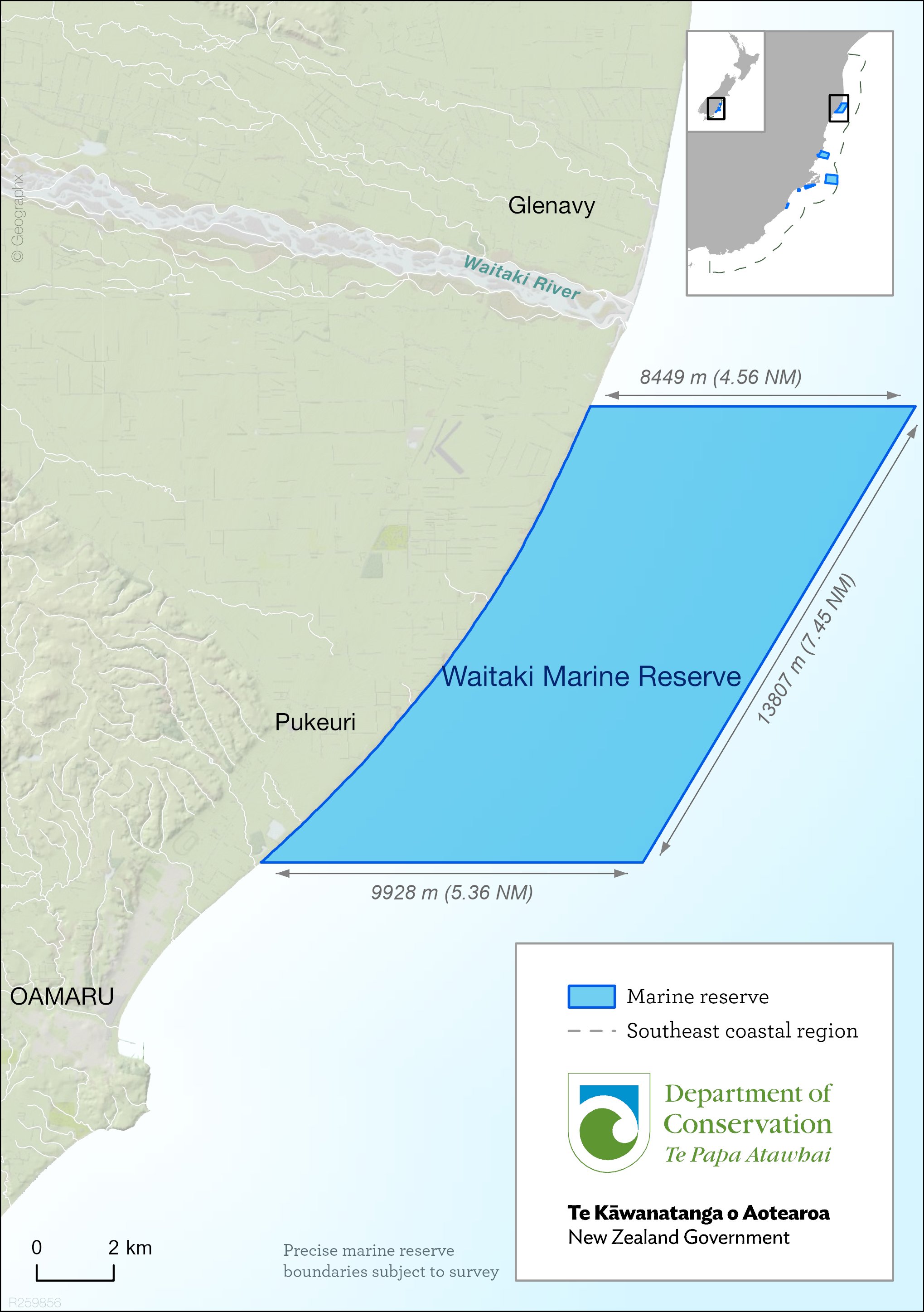
- Waitaki Marine Reserve, 101 km2 (JPG, 2,174K)
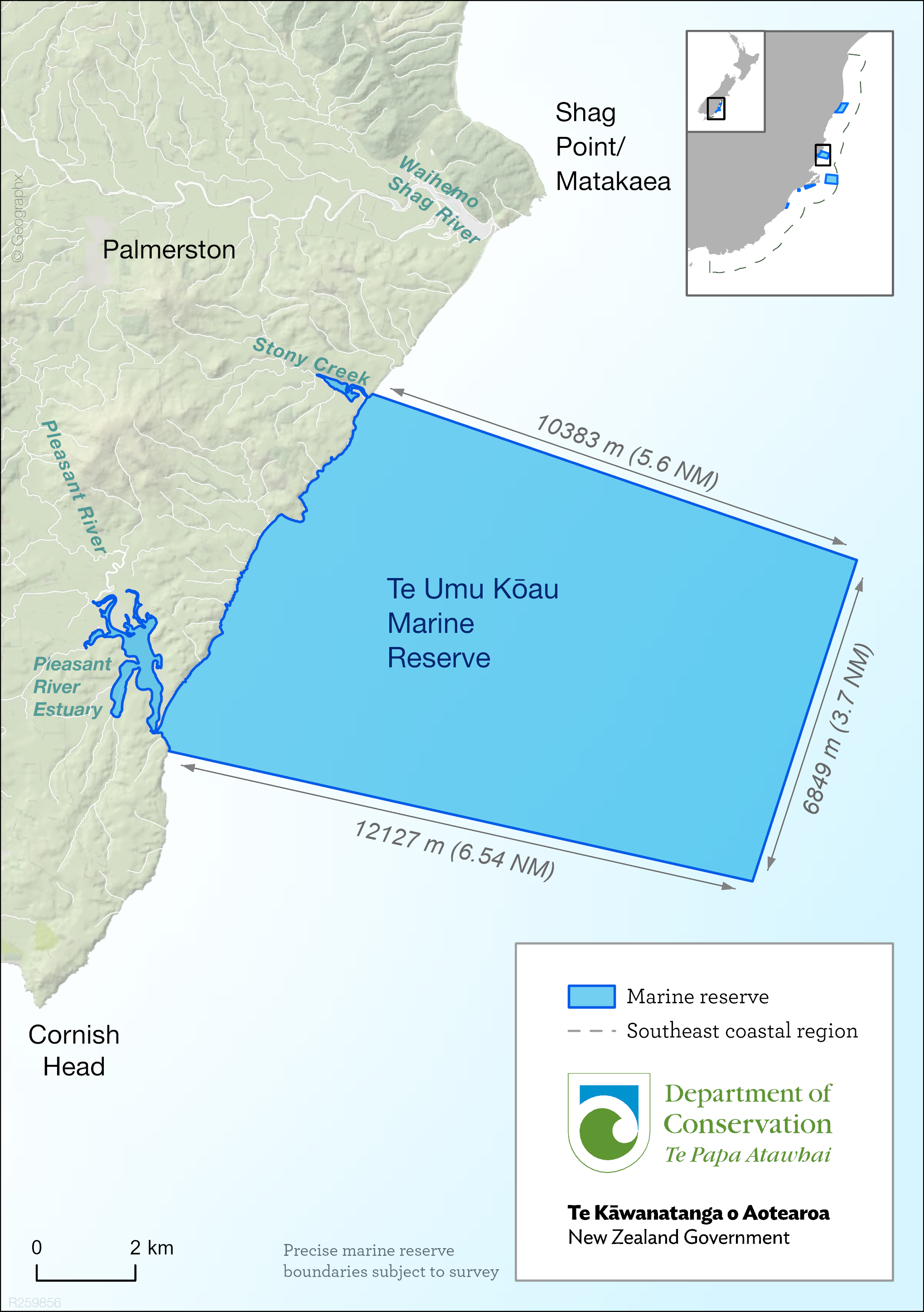
- Te Umu Kōau Marine Reserve, 88 km2(JPG, 2,066K)
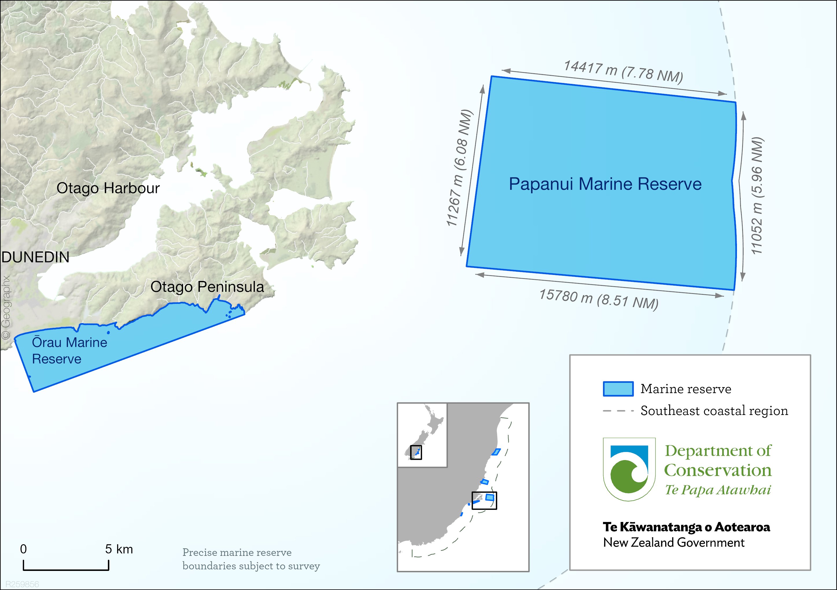
- Papanui Marine Reserve, 168 km2 (JPG, 1,790K)
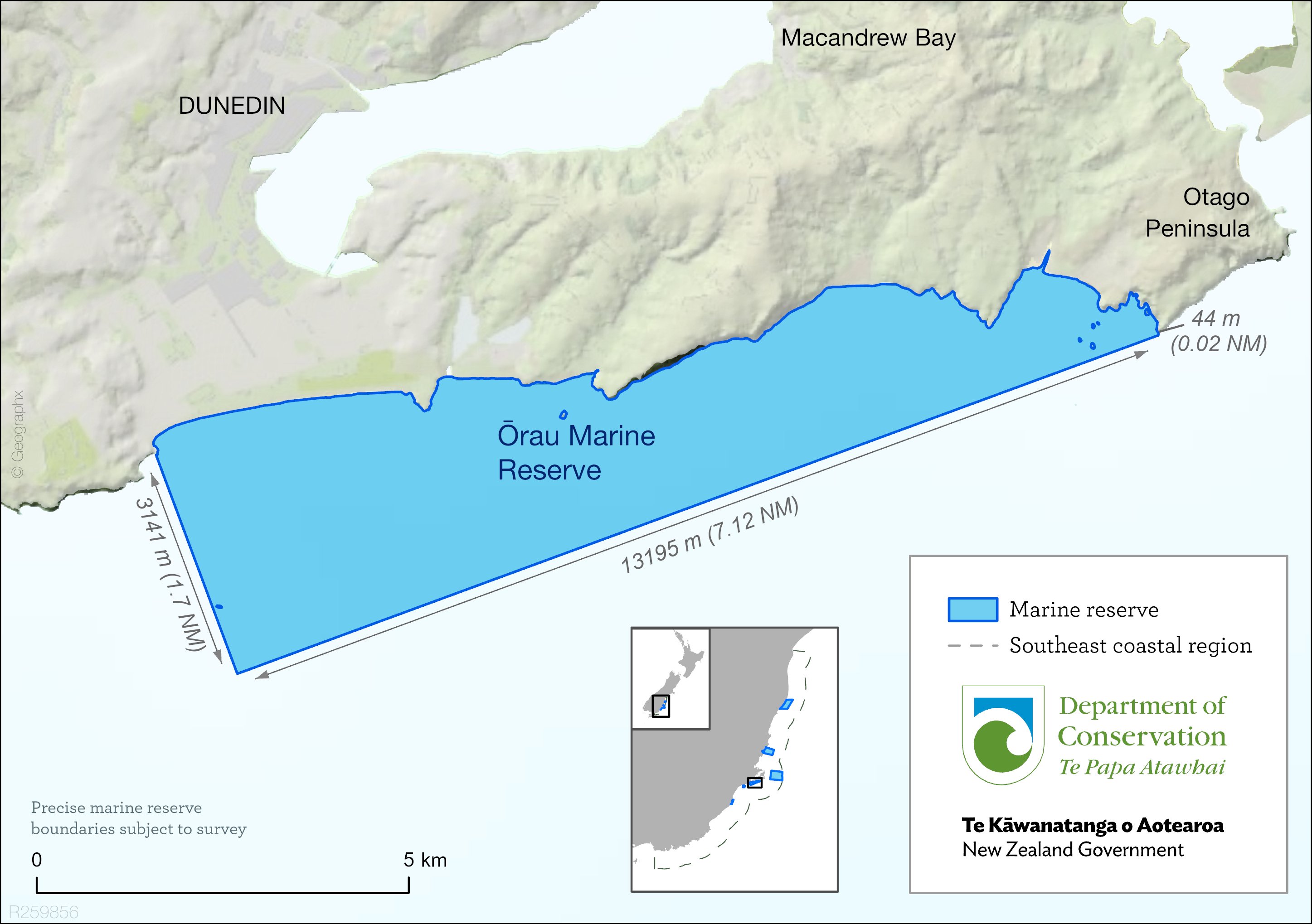
- Ōrau Marine Reserve, 29 km2 (JPG, 1,884K)
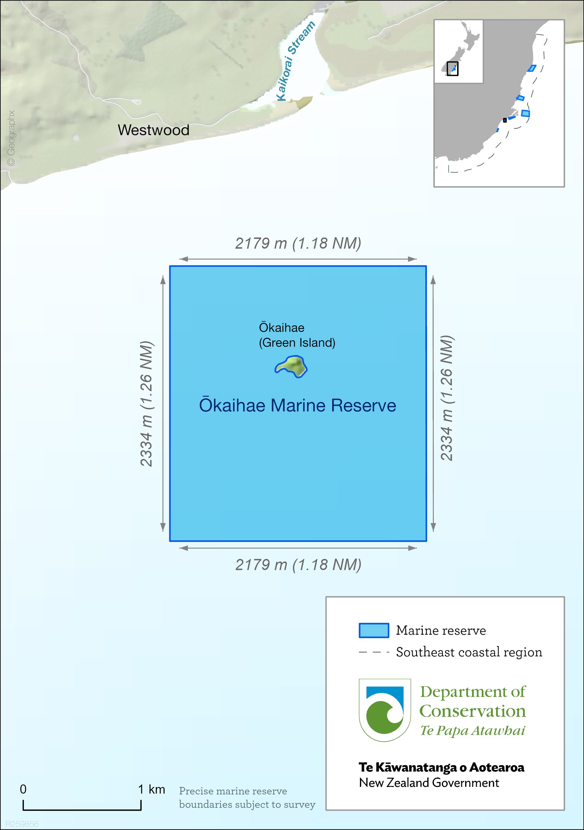
- Ōkaihae Marine Reserve, 5 km2 (JPG, 1,120K)
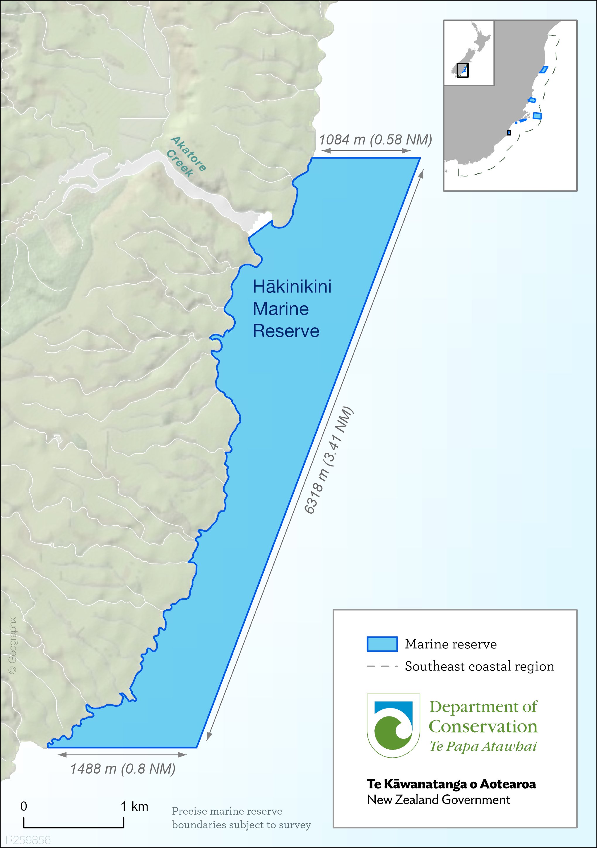
- Hākinikini Marine Reserve, 6 km2 (JPG, 1,829K)
Indicative shapefiles for the new marine reserves (ZIP, 50K)
Note: The shapefile boundaries of these marine reserves are indicative only. Boundaries will be finalised following surveys, which may result in slight changes, and will be confirmed as part of the gazettal process. Updated maps and spatial data will be provided closer to this time.
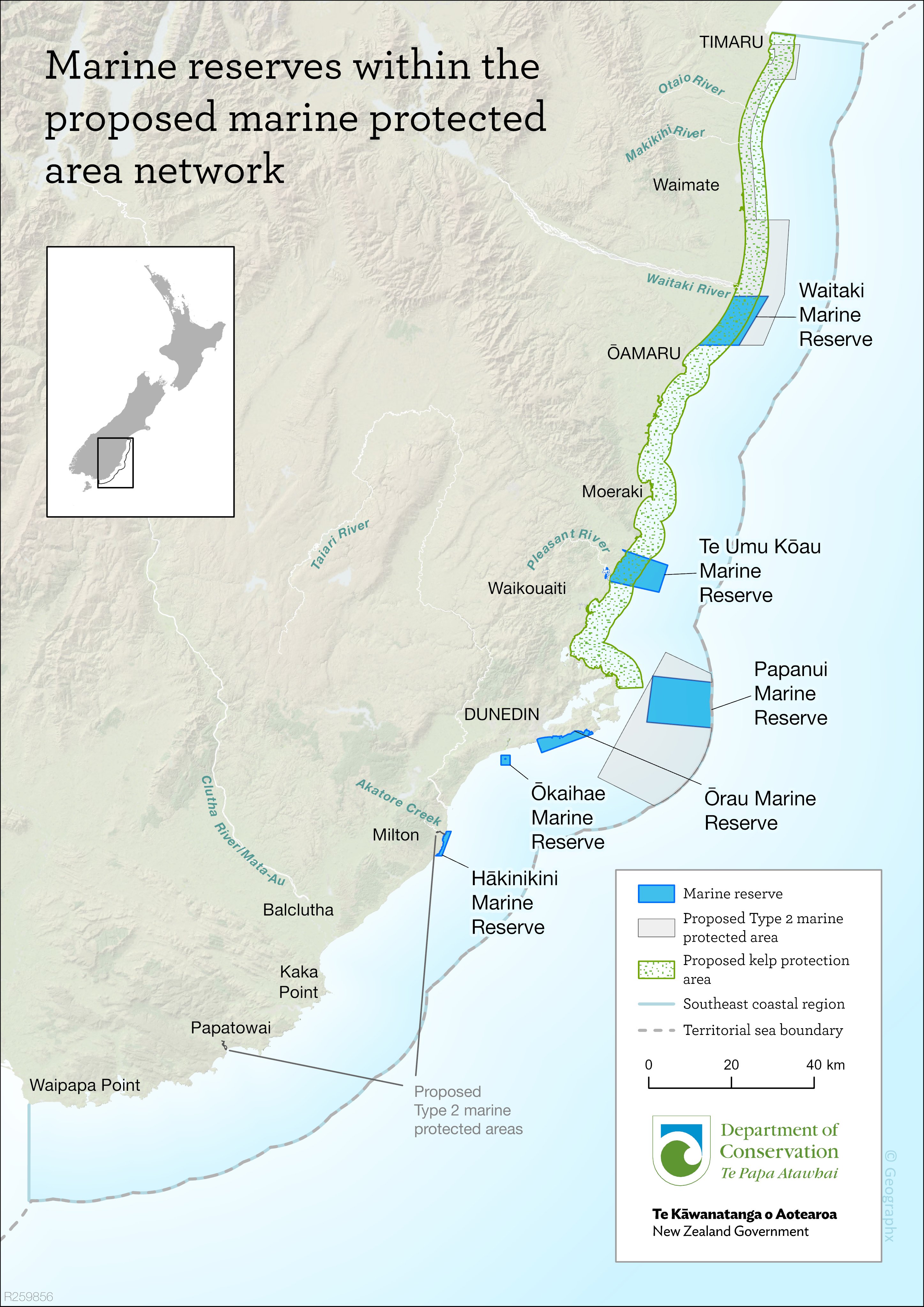
Southeast marine protection network
The marine reserves are part of a network of marine protected areas designed to protect the important marine habitats and biodiversity found in this coastal region.
The remainder of the proposed network consists of five Type 2 marine protected areas (where some forms of fishing would be prohibited) and a kelp protection area. These will be considered by the Minister for Oceans and Fisheries under the Fisheries Act.
Map showing location of marine reserves and Type 2 MPAs (JPG, 6,424K)
When the marine reserves will be in place
Five of the six marine reserves will come into force following an Order in Council and gazettal process, which is likely to be completed in the first half of 2026. Marine reserve boundaries will be surveyed and confirmed as part of the gazettal process. More information will be provided closer to this time.
Activities in these areas are not restricted until the marine reserves are formally in place.
DOC will work in partnership with Kāi Tahu to co-manage the marine reserves once they are in place.
Reconsideration of Te Umukōau Marine Reserve
As part of the agreed resolution of the judicial review of decisions on the six marine reserves, decisions by former Ministers to establish Te Umukōau Marine Reserve will be subject to a limited reconsideration regarding its boundary, following additional targeted consultation.
Judicial review of decisions for southeast South Island marine reserves
Recognition of customary rights
The six marine reserves are in the takiwā (tribal area) of iwi Kāi Tahu.
Kāi Tahu will be closely involved in managing the marine reserves in partnership with DOC.
Measures to recognise the customary rights of Kāi Tahu include allowing continued access to the marine reserves for the enhancement of mātauraka Māori (traditional knowledge) through wānaka (intergenerational sharing of knowledge). The retrieval of koiwi tākata (ancestral remains), artefacts, marine mammal remains, and some beach materials will also be provided for.
Fishing in marine reserves
As with other marine reserves in New Zealand, no commercial, recreational, or customary fishing under the Fisheries Act 1996 will be allowed in the new marine reserves once they are in place.
However, the Orders in Council will provide for Kāi Tahu to undertake wānaka (workshops) within the marine reserves to pass on mātauraka (traditional knowledge). This may include wānaka hī ika (lessons about traditional fishing) where take of some marine life may occur in a manner consistent with the purposes of the Marine Reserves Act. This is one way for Kāi Tahu to keep traditional knowledge and skills alive within their iwi, hapū and whānau and to connect their youth to their rohe moana (tribal marine areas).
Southeast marine protection process
Work towards the southeast marine protection network and new marine reserves has been underway since 2014.
A package of information comprising the Department’s advice, Ministerial decisions and supporting documentation (with some redactions) is available here: Official Information Act responses 2023.
Key steps were:
- the South-East Marine Protection Forum/Te Roopu Manaaki ki te Toka (with representatives from Kāi Tahu, commercial and recreational fishers, environment, science and tourism interests and local communities) was established in 2014 to consider and recommend marine protection options for the southeast coastal region
- after extensive consultation, the forum presented two options for marine protected area networks to the Government in 2018
- in 2019 the Minister of Conservation and Minister of Fisheries directed agencies to proceed with network one – comprising six marine reserves, five Type 2 MPAs and one kelp protection area
- in 2020 DOC and Fisheries New Zealand undertook public consultation on the proposed marine protection network
- public consultation occurred from June to August 2020, and 4,056 submissions were received
- DOC and FNZ continued to engage with Kāi Tahu and developed their respective advice to Ministers, considering the feedback from consultation
- in 2023 the Minister of Conservation approved the six marine reserves and gained the agreement of the Minister for Oceans and Fisheries and Minister of Transport.
More information about the process: