Mt Holdsworth - Jumbo Circuit
Located in Holdsworth area and Tararua Forest Park in the Wairarapa region
|
Introduction
The classic Mt Holdsworth - Jumbo Circuit is a two to three day tramp involving a climb through beech-podocarp forest to some of the best alpine tops travel in the Tararua Forest Park.- One of the four classic tramps in the Tararuas.
- Reach the open tops of the Tararuas within a few hours walk from a road end.
- From the top of Mount Holdsworth savour 360 degree views of the greater Wellington region.
24 km loop
Seasonal restrictions
The annual Atiwhakatu Trailblazer mountain biking fun ride is held in January each year. The exact date will be advised closer to the time.
Dog access
Image gallery
-
Mt Holdsworth Track Image: Julia Wells ©
![Mt Holdsworth Track. Mt Holdsworth Track.]()
-
Mt Holdsworth Track Image: Julia Wells ©
![Mt Holdsworth Track. Mt Holdsworth Track.]()
-
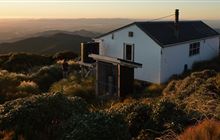
Jumbo Hut Image: Jack Mace ©
![Jumbo Hut at sunset. Jumbo Hut at sunset.]()
-
Powell Hut Image: Jack Mace ©
![Powell Hut. Powell Hut.]()
-
Low visibility conditions are common on the circuit Image: Tony Graham ©
![An image of the circuit with very low visibility. An image of the circuit with very low visibility.]()
-
Mt Holdsworth - Jumbo Circuit Image: Jack Mace ©
![Holdsworth. Holdsworth.]()
The loop track is described walking from Holdsworth roadend to Powell Hut, Mt Holdsworth, Jumbo Hut, returning to the roadend via the Atiwhakatu track.
Holdsworth Lodge - Powell Hut
Time: 4 hr
Starting from Holdsworth Lodge, carry on along the gravel track, cross the bridge over the Atiwhakatu Stream and follow the Gentle Annie track to Mountain House Shelter. This track is well graded and offers several lookout points to Mounts Holdsworth and Jumbo - for a short side trip follow the signpost to the Rocky Lookout, which offers good views over the Wairarapa. Mountain House Shelter is a pleasant resting spot.
Past Mountain House Shelter the track climbs steeply through dense bush and out onto the open tops. Powell Hut is located on the bush edge.
Powell Hut - Jumbo Hut
Time: 4 hr
Follow the track leading north-east along the main ridge to the Mt Holdsworth trig (1470 m).
Follow the exposed ridge north to Jumbo Peak (1405 m). The track then descends east along a spur to Jumbo Hut.
Caution: Beware of high winds, mist and icy underfoot conditions on all country above the bushline. The open tops are often not marked and difficult to negotiate in misty conditions. Those tramps should only be attempted by experienced trampers.
Jumbo Hut - Holdsworth Lodge
Time: 4 hr
The main track to Atiwhakatu Hut is via Raingauge Spur. Descend on the benched track immediately below Jumbo Hut. Once in the bush, follow the track down Raingauge Spur to Atiwhakatu Hut. A rain gauge was once located in a clearing half- way down the ridge.
There is a section of re-routed track subsiding on this section of the circuit. Proceed with caution when walking along this slip section.
From Atiwhakatu Hut, follow the Atiwhakatu track to Holdsworth Lodge.
Turn off State Highway 2 onto Norfolk Road, 2 km south of Masterton. This is signposted and there is a timber processing plant on the corner. Follow Norfolk Road 15 km to Holdsworth road end.
Daily rail and regular bus services operate between Wellington and Masterton. Taxis, or for large parties prebooked buses, can be hired for travel between Masterton and Holdsworth.
There is a large carpark at the Mount Holdworth Road end, which services the entry to the Tararua Forest Park.
What to expect
- The section of track between Powell and Jumbo Huts experiences frequent strong winds, thick mist, freezing temperatures and rain/snow. Be prepared to encounter these conditions at any time of year, even if the weather looks nice in the morning.
- The track is generally formed, but you will need to clamber over tree routes and go through rough and muddy sections.
Think carefully about whether to cross the tops and be open to turning back
When the weather turns bad, the route between Powell and Jumbo Huts becomes very challenging and potentially deadly. Thick mist makes navigation difficult and wind, rain and cold can quickly cause hypothermia.
Know your limits
Before leaving Powell/Jumbo Hut to cross the tops, look carefully at the weather and assess whether you have the experience and equipment for the conditions. If in doubt, wait for the weather to improve or turn back and save the alpine section for another day.

This photo was taken on Jumbo near the turnoff to Mt Holdsworth. Image: Tony Graham ©
Plan and prepare for your trip
When packing, take plenty of warm and waterproof clothing and we recommend an emergency shelter and distress beacon. Pack a map and compass or GPS and know how to use them. Walking poles may help keep you steady.
If you are trail running the track, you still need to be prepared for bad weather.
The circuit involves a climb through beech-podocarp forest to some of the best alpine tops travel in the park. The bush tracks are well marked and signposted and streams are bridged. The route on the open tops is marked with blue poles.
Stay safe in the outdoors
- Choose the right trip for you. Learn about the route and make sure you have the skills for it.
- Understand the weather. Check weather forecasts.
- Pack warm clothes and extra food. Check gear lists.
- Share your plans and take ways to get help. Share directly or use the Outdoor Intentions form or Plan My Walk. Take a distress beacon.
- Take care of yourself and each other.
Contacts
| Wellington/Kapiti information | |
| Phone: | +64 3 546 9339 |
| Email: | nelsonvc@doc.govt.nz |
| About: | Whakatū/Nelson Visitor Centre provides visitor information for this area |


