The circuit follows open coastline, crosses forested interior and meanders along the sheltered shores of Paterson Inlet. It passes sites of historical interest and introduces many of the common sea and forest birds of the island. Parts of it cross Māori land and access is courtesy of the owners.
Listen out for the Rakiura tokoeka/kiwi calling or look for its footprints
Immerse yourself in history, from early Māori settlement sites to sawmilling relics.
The campsites are not adjacent to the huts. Camping is only allowed at these designated campsites. When camping, you may not use hut facilities, but a cooking shelter, water supply and toilet are provided at each site.
Oban township to Lee Bay
Time: 1 hr 30 mins Distance: 5 km
Lee Bay to Port William Hut
Time: 3 to 4 hr Distance: 8 km
Passing through the chain link sculpture at Lee Bay, the track follows the coast to Little River, which is crossed by a bridge. At low tide it is possible to walk around the beach and pick up the track at the point.
From there the track heads around Peter’s Point and on to Maori Beach. The creek at the southern end of Maori Beach can easily be waded at low tide, however at high tide, continue along the track until you come to a small foot bridge. A track leading to a rusting steam boiler, a relic from the sawmilling days, can be found just few minutes on from the turn-off to this bridge. Maori Beach campsite is situated in a grassy clearing close to the beach.
A larger bridge spans the tidal stream at the northern end of the beach and from here the track climbs a small hill and continues on to the intersection with the track to North Arm. Turn right and you will gradually drop down to the campsite above Magnetic Beach in Port William/Potirepo. Port William Hut is just a few minutes beyond the campsite.
This section of track starts on the hill between Maori Beach and Port William. Trampers usually stay the night at Port William Hut and then backtrack the 40 minutes to the turn-off.
The track passes through a variety of vegetation including previously milled and virgin podocarp forest. Remnants of milling activity are seen along the track as it follows old tramlines for the logs being directed to their various destinations.
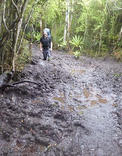
Very muddy parts
During long periods of rain the track can get so muddy that the mud goes above boot height. The muddy areas can be up to 500 m long and also muddy in smaller sections. Gaiters are recommended as the mud can reach above footwear level. Some people also prefer to use tramping poles along this section.
This section of track provides trampers access to the shores of Paterson Inlet.
The track sidles around the headland from North Arm to Sawdust Bay.It passes a sawmill site which was operated between 1914 and 1918. The track continues through rimu and kamahi dominated forest emerging at the sheltered bays of Kidney Fern Arm and Kaipipi Bay. At Kaipipi Bay two sawmills employed more than 100 people in the 1860s.
The track between Kaipipi and Halfmoon Bays follows the former Kaipipi Road, in its heyday the most used and best maintained on the island.
Fern Gully car park to Oban township
it is another 2 km along the road (turn left into Main Rd) to get back to Oban township.
Hut fees
Prices are per person, per night. NZ rates are for New Zealand visitors and INT rates are for international visitors.
All huts and campsites on the Rakiura Track must be booked in advance all year round.
If you don’t have a valid booking for your stay, you may be charged a penalty, or turned away if the hut/campsite is full.
The maximum stay at each hut/campsite is 2 nights.
Getting to the start of the Rakiura Track
The Rakiura Track can be walked in either direction, starting from two locations:
The official entrance to Rakiura National Park at Lee Bay, 5 km from Oban. If walking from the DOC visitor centre in Oban, turn right and walk down Main Road. Turn left into Elgin Terrace, past the supermarket, and up the hill. Follow this main coastal road over a series of hills to Horseshoe Bay, then on to Lee Bay.
The Fern Gully car park, 2 km beyond the Rakiura National Park Visitor Centre, which is located on Main Road in Oban.
If you prefer not to walk from Oban, shuttles can be used for drop-offs at Lee Bay or water taxis can be used for access to Rakiura Track huts.
Access to North Arm hut by boat is dependent on tides.
Getting to Stewart Island/Rakiura
To get to Oban, the only township on Stewart Island/Rakiura, you can take a 20-minute flight from Invercargill or a 1-hour ferry trip across Foveaux Strait from the southern port of Bluff. In Oban you’ll find accommodation, supplies, equipment hire and transport to and from the start of the track.
Stewart Island’s weather is very changeable and difficult to predict. Strong winds, hail and heavy rain can occur at any time of the year. Check the Rakiura National Park weather forecast – NIWA website.
Sections of deep mud
During long periods of rain the track can get so muddy that the mud goes above boot height.
This occurs between Port William Hut to North Arm Hut. The muddy areas can be up to 500 m long and also in smaller sections.
Sturdy footwear and gaiters are recommended as the mud can reach above footwear level. Some people also prefer to use tramping poles along this section.
Safety is your responsibility
Mobile coverage is restricted to the immediate township so consider carrying a distress beacon.
Share your plans with a trusted contact before your trip. Also fill in the hut books and include any change of plans.
Keep to the tracks. Off the tracks the valleys are steep-sided and densely bush-clad.
Exposed netting on the track
Be careful where netting is exposed and on wooden steps, these sections may be slippery.
Bring a copy of the DOC confirmation letter with you, or stop by the Rakiura National Park Visitor Centre at Oban before you start walking on the track.
Huts on the Rakiura Track don't have gas cooking facilities, lighting or toilet paper. Remember to take a portable stove and fuel, candles and toilet paper with you.
Personal equipment
Backpack – 40–60 litre size for multi-day hiking
Waterproof/plastic pack liner
Sleeping bag – 3–4 season
First aid kit including blister treatment materials
Survival kit including survival blanket, whistle, paper, pencil, high energy snack food
Safety equipment relevant to the track and time of year, for example, map, compass
For multi-day walking you'll need at least one set of clothes to walk in and another dry set to change into at night.
Tramping/hiking boots or firm footwear – should be comfortable and well broken in
Socks – wool or polypropylene
Shorts – quick dry material
Shirt – wool or polypropylene
Under layers, top and bottom – wool or polypropylene
Mid-layers – wool or polar fleece
Raincoat – waterproof, windproof with hood
Overtrousers – wind and waterproof
Warm hat and gloves
Sunhat and sunglasses
Extra socks, underwear, shirt/lightweight jersey
Optional
Gaiters
Lightweight shoes for inside the huts
Food
You cannot buy food on the track. Carry all the meals and snacks you will need, plus some spare, and a water bottle. We recommend food that is lightweight, fast cooking and high in energy value.
We do not provide emergency food in huts. You will need to carry emergency food supplies in case you are delayed by weather.
Store your food in a rodent-proof container or bag. This is especially important if you are camping.
Diverse native birdsong, lush forest, relics of bygone days, beaches and rugged coastlines are all features of this year-round Great Walk.
Port William
Maori established hunting camps or kaika at many coastal sites, including Port William/Potirepo, reached by outrigger canoe. Port William/Potirepo was the site of the early Maori settlement of Pa Whakataka.
During the 1800s its sheltered harbour was used by sealers and later as a whaling base. Gold prospecting was unsuccessful but the discovery of an oyster bed proved more lucrative. A government subsidised settlement by Shetland Islanders lasted only a short time, the bay’s gum trees the only remains of their presence.
Maori Beach
In the early 1900s, timber milling developed at Maori Beach which, by 1920, had two sawmills and a school. From the track, you’ll be able to see remains of the sawmilling enterprise which lasted here until 1931.
Paterson Inlet
The sheltered waters of Paterson Inlet/Whaka a Te Wera were used early in the 19th century by whaling boats. However, the first large scale industry here was in timber, beginning in 1861 with the opening of sawmills at Kaipipi.
In the 1920s and 1930s the Norwegian Whaling Company ran a repair base in Prices Inlet where chaser boats were serviced in preparation for the Antarctic summer.
The “link track”
First established in the 1980s, the walking track linking Port William with Paterson Inlet has been improved and upgraded to take walkers past relics of the timber milling days.
Diverse forest
The Rakiura Track takes walkers through mainly rimu and kamahi forest with a rich diversity of tree ferns, ground ferns and perching orchids. Rata is more common at higher altitudes.
A wonderland for bird watching
Along the coast, keen bird watchers should look out for mutton birds/tïtï (sooty shearwaters), shags/kawau, Buller’s mollymawks/toroa, cape pigeons/titore and little blue penguins/korora.
In the forest, walkers may see and hear bellbirds/korimako, tui, fantails/pïwakawaka, parakeets/kakariki, shining cuckoos/pipiwharauroa and wood pigeons/keruru, grey warblers/riroriro, kaka and tomtits/miromiro.
The tidal flats of Paterson Inlet host a variety of wading birds including the New Zealand dotterel/tūturiwhatu, oyster catchers/torea, herons/matuku moana and godwits/kuaka.
There are many kiwi on Stewart Island. Kiwi are nocturnal, and most are active during the night. Use a red light or red filter to cover your torch to minimise disturbance when looking for kiwi. Do not use flash photography or bright lights.
Stay safe in the outdoors
Choose the right trip for you. Learn about the route and make sure you have the skills for it.
