
60 km one way
Image gallery
Video
Highlights
- Discover Cleopatra's Pool – natural rock pool with a moss-lined waterslide.
- Admire the beautiful inlet to Falls River as you walk across a 47 m suspension bridge.
- Keep an eye out for fur seals/kekeno.
- Crystal-clear waters of Tonga Island Marine Reserve.
Explore on Google Street View | Watch videos | Download the free visitor app
What to expect
The track is well marked and signposted, but some sections may be steep and rough and the track could be muddy.
There is one compulsory tidal crossing – check the tide tables for when it's safe to cross.
Walking options
Walk the whole track in either direction, take a water taxi or kayak between different locations.
Places to stay
There are 4 huts and 18 campsites along the Abel Tasman Coast Track, which must be booked in advance all year round. Visitors arriving without a valid booking, or staying at a hut or campsite other than the one named on their ticket, will be charged a penalty fee or may be asked to leave the park.
Note, campsites are designed for tents and are not suitable for hammocks. Campers are not permitted to use hut facilities.
Marahau to Anchorage
Time: 4 hr
Distance: 12.4 km
You’ll begin your journey as you cross the estuary over the Marahau causeway, and follow the track, first through open country, then lush beech forest with large kānuka trees. The track eventually turns inland, winding in and out of several little gullies before emerging to a view of the beautiful Anchorage Bay. Here you’ll descend to Anchorage Hut and Campsite.
Side trip: Tinline Bay Nature Walk
Time: 20 min return
Home to a bizarre tree growing in an unusual place.
Campsites and huts between Marahau and Anchorage
- Tinline Campsite
- Coquille Bay Campsite
- Apple Tree Bay Campsite
- Akersten Bay Campsite
- Watering Cove Campsite
- Observation Beach Campsite
- Te Pukatea Bay Campsite
- Anchorage Campsite
- Anchorage Hut
Anchorage to Bark Bay
High tide track
Time: 4 hr
Distance: 11.5 km
Low tide crossing, Torrent Bay estuary
Time: 3 hr
Distance: 8.4 km
Torrent Bay estuary can be crossed within 2 hours either side of low tide, or you can take the all-tide track around it. An impressive 47-metre long suspension bridge takes you over Falls River. You’ll then meander through lush coastal forest before being led back to the sea and the idyllic golden sands of Bark Bay.
Suspension bridge on Google Street View
Side trip: Cascade Falls
Time: 1 hr 30 min return
A beautiful waterfall hidden in native bush that’s a great spot to cool off. The track is quite steep in parts.
Side trip: Cleopatra's Pool
This beautiful rock pool with clear cool water is a nice swimming hole.
Campsites and huts between Anchorage and Bark Bay
Bark Bay to Awaroa
Time: 4 hr 30 min
Distance: 13.5 km
Cross the beautiful Bark Bay estuary 2 hours either side of low tide or follow the all-tide track (10 minutes) around the edge of the estuary. A steep climb takes you through stands of mānuka. Return to the coast at Tonga Quarry and it’s a short walk from there to Onetahuti Bay, where one of the longest beaches in the Abel Tasman stretches before you.
The track then leads over the forested Tonga Saddle. At the junction just beyond the saddle, either stay on the main track around and down to Venture Creek, following the path up the hill to a lookout point over Awaroa Bay, before dropping down to walk to Awaroa Campsite and hut. Alternatively, if you need to catch a water taxi, turn right at the junction and take the non-DOC track down to the beach. At low tide, it is possible to follow the beach below the high tide mark around the inlet and wade across to Awaroa Hut and Campsite.
Take care to stay below the high tide mark away from nesting birds.
Onetahuti Bay on Google Street View
Campsites and huts between Bark Bay and Awaroa
Awaroa to Whariwharangi Bay
Awaroa to Tōtaranui
Time: 2 hr 20 min
Distance: 7.1 km (tidal)
Tōtaranui to Whariwharangi Bay
Time: 3 hr 15 min
Distance: 9.8 km
Awaroa Inlet can only be crossed within 1 hour 30 minutes before and 2 hours after low tide. Along the track, the scenery alternates between sandy beaches and rocky headlands of regenerating kānuka. Camp or stay in the cosy and historic Whariwharangi Hut (a former homestead built around 1896) just behind the beach.
Campsites and huts between Awaroa and Wainui
- Waiharakeke Bay Campsite
- Tōtaranui Great Walk Campsite
- Anapai Bay Campsite
- Mutton Cove Campsite
- Whariwharangi Bay Campsite
- Whariwharangi Bay Hut
Whariwharangi Bay to Wainui
Time: 2 hr
Distance: 5.7 km
Follow a trickling stream and climb above the bay to a saddle overlooking the serene Wainui Inlet. The inlet is a great place to swim or to explore rock pools. The track winds down to the shore and follows the estuary edge to the car park.
Whariwharangi Bay to Tōtaranui
Time: 3 hr
Distance: 9 km
From Whariwharangi Hut follow a small stream, then climb out of the bay to a low saddle overlooking Wainui Inlet. At this point take a left turn onto the Gibbs Hill Track. This track will take you over the steep Gibbs Hill then back down to Tōtaranui.
From Tōtaranui you can get a water taxi back to Mārahau, ensure you allow enough time to walk to Totaranui. Refer to your water taxi provider for their pick up and drop off locations and timetable.
Note this is a shared-use track. Mountain biking Wainui – Gibbs Hill – Tōtaranui is allowed from 1 May to 30 September at any time of the day. There is a maximum group size of eight riders.
Abel Tasman Coast Track virtual guide
Watch a NZ Mountain Safety Council video.
Fees are charged per person, per night to stay in huts and campsites on the Abel Tasman Coast Track. There are no fees to complete a day walk on the track or for entry into the Abel Tasman National Park.
Pay your fees by booking the huts and/or campsites before you start the track.
Prices are per person, per night. NZ rates are for New Zealand visitors and INT rates are for international visitors.
Huts
|
Date range |
Adult NZ |
Adult INT |
Child NZ |
Child INT |
Infant NZ |
|---|---|---|---|---|---|
|
1 October – 30 April |
$55 |
$84 |
$28 |
$42 |
Free |
|
1 May – 30 June |
$42 |
$42 |
$21 |
$21 |
Free |
|
1 July – 31 August |
$33 |
$33 |
$17 |
$17 |
Free |
|
1 - 30 September |
$42 |
$42 |
$21 |
$21 |
Free |
Proof of eligibility is required for the New Zealand rate.
Prices are per person, per night. NZ rates are for New Zealand visitors and INT rates are for international visitors.
Campsites
|
Date range |
Adult NZ |
Adult INT |
Child NZ |
Child INT |
Infant NZ |
|---|---|---|---|---|---|
|
1 October – 30 April |
$21 |
$31 |
$10 |
$15 |
Free |
|
1 May – 30 September |
$21 |
$21 |
$10 |
$10 |
Free |
Proof of eligibility is required for the New Zealand rate.
Bookings
Huts and campsites must be booked in advance year round. Book the Abel Tasman Coast Track online
Check the tide timetables before you book. You can only cross Awaroa Inlet in daylight, and within 1 hour 30 minutes before and 2 hours after low tide. Make sure your trip plan will fit this.
We also recommend checking transport times before booking, if you plan to use a shuttle or water taxi. Find shuttle services and water taxis for the Abel Tasman Coast Track.
If you don’t have a valid booking for your stay, you may be charged a penalty, or turned away if the hut/campsite is full.
Note: You can only book each hut/campsite for a maximum of two nights (1 October – 30 April) or five nights (1 May to 30 September). Tōtaranui Campsite can only be booked for one night all year.
School bookings
School groups are only permitted to book to camp at Tinline, Apple Tree, Anchorage, Bark Bay, Onetahuti, Awaroa, Totaranui, Mutton Cove and Whariwharangi campsites.
School groups are not permitted to book at any of the other Abel Tasman campsites for any reason. Bookings made at any campsite not named above will be cancelled.
School bookings are limited to a maximum of 40 youths (with no limit on adult helpers) per site, per night.
You may use A1, A2, etc for adults and S1, S2, etc for students when you book, but the names of all adults must be added before you arrive. The numbers of adults and students in your booking must be correct on entering on the park or you may be charged extra fees.
The Abel Tasman Coast Track has four main entrances
Marahau is the southern gateway
It's 67 km from Nelson on sealed road providing access by water taxi, kayak, or walking
Wainui is the northern entrance
It's 128 km from Nelson and 21 km from Takaka. For the last 2 km, the road is unsealed providing access by walking
Totaranui
Totaranui is 160 km from Nelson and 32 km from Takaka providing access by walking and water taxi. The last 12 km of the road is unsealed but suitable for campervans.
Kaiteriteri
Kaiteriteri is 61 km from Nelson providing access by kayak or water taxi. Note: This is 7 km from the track entrance by walking and it is not advisable to walk this.
It is also possible to access Awaroa estuary on a road that is 31 km from Takaka. The last 12 km of road is rough, unsealed and prone to flooding. It is not recommended as an entrance to the Park.
Transport options
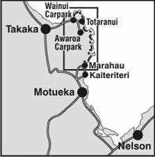
Abel Tasman Coast Track locality map
Most visitors only walk in one direction on the Coast Track and get a water taxi in the other direction.
There are commercial water taxis that operate between Marahau/Kaiteriteri and Totaranui. Water taxis are not permitted to go above Totaranui, so there is no service to Wainui or any of the Northern bays. Visitors travelling beyond Totaranui use the Gibbs Hill Track to make a loop in the Northern end of the Park.
You can make a 5–7 day circuit using the Abel Tasman Inland Track. However, the Inland Track is very steep, rough underfoot and does not have many viewpoints.
Water taxis operate year round and must be booked in advance. The scheduled water taxi pickup locations are Apple Tree Bay, Anchorage, Medlands Bay, Bark Bay, Tonga Quarry, Onetahuti, Awaroa and Totaranui.
Many of the water taxi and kayak companies have shuttle buses for their clients.
Vehicle parking
DOC provides a carpark at Marahau, Totaranui and Wainui road ends. Cars are parked at your own risk.
There is strictly no freedom camping.
Water taxi and kayak operators have their own private car parking for clients.
 No unauthorised drone use in the national park
Unauthorised use of drones is prohibited. You must have a permit to fly a drone.
DOC does not generally approve permits to fly drones in this national park and we do not recommend you apply for one.
Track conditions
Check with visitor centres for any track updates and important notices, including closures or maintenance on huts, campsites, roads and tracks – also listed on Nelson/Tasman alerts.
Drinking water
Water at the huts and campsites is not treated, boil before use.
Tide times
Be sure to consult a tide timetable when planning your trip as the Awaroa estuary area on the track is only passable at low tide.
Tsunami risk
The New Zealand coastline is at risk from tsunamis, including the Abel Tasman Coast Track and its huts and campsites. If you feel a long or strong earthquake, see a sudden rise/fall in sea level, or hear loud/unusual noises from the sea, go to higher ground immediately.
Fill in the visitors book if you are staying in a hut.
Weather
The climate is mild with sea breezes, summer droughts and some winter frosts. Rainfall averages 1800mm and the sun shines around 2200 hours per year. During late spring and throughout summer the coast is subject to strong westerly winds, while the autumn and winter months are generally calm. Abel Tasman National Park weather forecast – NIWA website.
Average Temperatures
Table showing average temperatures on Abel Tasman Track.
Winter
The Abel Tasman Coast Track can be walked all year and is busiest from October to April. Winter is generally quiet, with fewer insects, calmer water, cooler temperatures and shorter daylight hours. All huts have heating. Campsites that get good afternoon sun are Anchorage, Bark Bay, Mosquito Bay, Awaroa and Tōtaranui.
Supplies
Full list of what to take on Abel Tasman Coast Track.
Wasps and sandflies
There are wasps and sandflies. We recommend carrying insect repellent for sandflies and your medication if you are allergic to wasp stings (such as antihistamines).
There are some crossings on the Abel Tasman Coast Track that should only be made at low tide. Do not cross when it's not low tide as it's dangerous.
Where you need to do low tide crossings
Torrent Bay Estuary
- This can be crossed 2 hours on either side of low tide, under normal conditions.
- There is an all tide track around the estuary. This gives access to Cleopatra’s Pool.
Awaroa Inlet
- You can cross Awaroa Inlet within 1 hour 30 minutes before and 2 hours after low tide. Although this can be affected by natural influences such as tide heights, storm surges, and heavy rainfall.
- Only cross the inlet in daylight when it's safe.
- Allow 25 minutes to cross.
- No alternative track around the estuary.
Goat Bay
- There is a section of the access to the beach that is cut at large tides.
- Wait until the tide recedes before continuing.
Low tide timetables
Download
- March 2026 – June 2026 (PDF, 63K)
- July 2026 – October 2026 (PDF, 59K)
- November 2026 – February 2027 (PDF, 59K)
- March 2027 – June 2027 (PDF, 59K)
- July 2027 – October 2027 (PDF, 59K)
View as tables
Huts on the Abel Tasman Coast Track don't have gas cooking facilities and lighting. Remember to take a portable stove and fuel, and candles with you.
It's not possible to dry clothes in the huts. Cotton clothing such as jeans, T-shirts and sweatshirts aren't suitable.
The use of hammocks, including "tree hugger" hammocks, is not permitted in campsites on the Abel Tasman Coast Track.
Personal equipment
- Backpack – 40–60 litre size for multi-day hiking
- Waterproof/plastic pack liner
- Sleeping bag – 3–4 season
- First aid kit including blister treatment materials - see Mountain Safety Council first aid advice
- Survival kit including survival blanket, whistle, paper, pencil, high energy snack food
- Safety equipment relevant to the track and time of year, for example, map, compass
- Torch/flashlight and spare batteries
- Rubbish bag
- Booking confirmation and ID
- Earplugs for communal bunkrooms
Cooking and food equipment
- Drink bottle – 1–2 litre capacity
- Eating and cooking utensils – knife, fork, spoon, plate, cup, pot/pan/billy, cleaning kit, tea towel
- Gas cooker and fuel, for example, gas canister
- Matches or lighter in waterproof container
Toiletries
- Toiletries, including insect repellent, sunscreen, and personal medication, for example, antihistamine for allergy to wasp stings
- Use a toilet when you see one and be prepared with a backup toilet option
If camping
- Tent
- Sleeping mat
- Ground sheet
Clothing
- For multi-day walking you'll need at least one set of clothes to walk in and another dry set to change into at night.
- Tramping/hiking boots or firm footwear – should be comfortable and well broken in
- Socks – wool or polypropylene
- Shorts – quick dry material
- Shirt – wool or polypropylene
- Under layers, top and bottom – wool or polypropylene
- Mid-layers – wool or polar fleece
- Raincoat – waterproof, windproof with hood
- Overtrousers – wind and waterproof
- Warm hat and gloves
- Sunhat and sunglasses
- Extra socks, underwear, shirt/lightweight jersey
Optional
- Gaiters
- Lightweight shoes for inside the huts
Food
You cannot buy food on the track. Carry all the meals and snacks you will need, plus some spare, and a water bottle. We recommend food that is lightweight, fast cooking and high in energy value.
We do not provide emergency food in huts. You will need to carry emergency food supplies in case you are delayed by weather.
Store your food in a rodent-proof container or bag. This is especially important if you are camping.
If you haven't kayaked before
For people who haven’t kayaked before, a guided trip is recommended. If you're renting a kayak or going on a guided trip, discuss your kayak trip with your chosen kayak operator before booking huts or campsites.
If you're not going on a guided trip
For independent kayak rentals, a minimum of two people and previous sea-kayaking experience are essential.
Kayaking weather dependant
Kayaking is more weather dependent than walking along the Coast Track. Abel Tasman National Park weather forecast – NIWA website.
Book campsites that are within your kayaking ability and plan for the worst weather – head winds and rough seas. Then, if the weather makes kayaking slow you will still get to your campsite. If the weather is fine and there is a tail wind, you can always kayak to your campsite, set up your tent and then go exploring with your kayak without your overnight gear.
Assess your fitness, the wind strength and direction and sea swell before proceeding each day. If the weather is too rough to safely kayak to your intended destination (the campsite you have booked), stop and wait for a few hours for sea conditions to improve.
Only camp at a campsite other than the one you have booked for safety reasons.
Never risk your life by kayaking in dangerous seas.
Paddling times
Rough paddling times for experienced kayakers in calm conditions without stops are:
- Marahau to Anchorage 4 hr
- Anchorage to Bark Bay 2 hr
- Bark Bay to Onetahuti 1 hr 30 min
Where kayaking is not recommended
Kayaking is not recommended north of Onetahuti Bay due to the remote and exposed coastline.
| Max temp ˚C | Min temp ˚C | Rainy days | |
|---|---|---|---|
| July | 13 | 4 | 11 |
| August | 13 | 5 | 10 |
| September | 15 | 7 | 12 |
| October | 17 | 8 | 9 |
| November | 19 | 10 | 10 |
| December | 21 | 12 | 10 |
| January | 23 | 12 | 6 |
| February | 22 | 13 | 7 |
| March | 21 | 12 | 9 |
| April | 18 | 10 | 8 |
| May | 16 | 7 | 10 |
| June | 14 | 6 | 10 |
Nature's in trouble
Thousands of New Zealand’s native species are heading towards extinction. Once they’re gone, they’re gone for good. Nature needs your help.
Stay safe in the outdoors
- Choose the right trip for you. Learn about the route and make sure you have the skills for it.
- Understand the weather. Check weather forecasts.
- Pack warm clothes and extra food. Check gear lists.
- Share your plans and take ways to get help. Leave your intentions with a trusted contact and take a distress beacon.
- Take care of yourself and each other.
Nelson/Tasman/Marlborough information
| Phone: | +64 3 546 9339 |
| Email: | nelsonvc@doc.govt.nz |
| About: | Whakatū/Nelson visitor services provide information for this area |