Lower and Upper Young hunting
Located in Mount Aspiring National Park east of the Divide hunting in the Otago region
|
Introduction
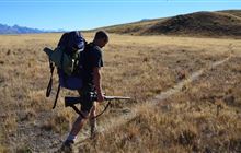
The forested valley of the Lower and Upper Young hunting block offers opportunities to hunt red deer and chamois.Species
- Chamois
- Deer - Red
Permit requirements
This hunting area is covered by an 'open area permit' – get it online or from a DOC office.
Seasonal restrictions
Before lighting a fire on public conservation land, check it's alright to light. Extinguish all fires before leaving huts and campsites. How to minimise the risk of fire.
Dog access
About this hunting block
Animals present are red deer and chamois, in low to moderate numbers.
General information
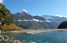
This block takes in the entire Young River catchment – a silver beech/tahina forested valley forming part of the popular Gillespie Pass Circuit.
The block divides into two separately balloted portions, lower and upper Young, for the roar period during March and April. The boundary is at the second flats E1293940, N5099390.
In 2007 a major slip in the North Branch of the Young dammed the river and formed a new lake. The dam still poses a potential risk to hunters and trampers and the Young Valley should be avoided during heavy rain.
Access
Access to the Young Valley is from Sawmill Flat on the Haast Highway (SH6), 4 km northwest of Makarora township. A stile and sign indicate the access point to the valley. If the Makarora River is too high to cross safely, alternative options are a commercial jetboat or the Young River Link Track.
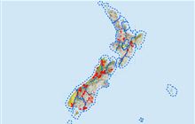
Maps
- NZTopo50 series: BZ12
- Lower Young hunting block map (PDF, 1838K)
- Upper Young hunting block map (PDF, 1652K)
Dogs
Dogs are not allowed in this block as it is part of Mount Aspiring National Park.
Huts
Contacts
| Tititea/Mount Aspiring National Park Visitor Centre | |
|---|---|
| Phone | +64 3 443 7660 |
| wanakavc@doc.govt.nz | |
| Address | 1 Ballantyne Road Wanaka 9305 |
| Hours | See visitor centre hours |