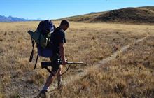
Dingle Burn hunting
Located in Hāwea Conservation Park hunting in the Otago region
|
Introduction
In the Dingle Burn hunting block, you can hunt red deer, tahr and chamois.Species
- Chamois
- Deer - Red
- Tahr
Permit requirements
This hunting area is covered by an 'open area permit' – get it online or from a DOC office.
Seasonal restrictions
Before lighting a fire on public conservation land, check it's alright to light. Extinguish all fires before leaving huts and campsites. How to minimise the risk of fire.
Dog access
About this hunting block
Animals present are red deer, tahr and chamois and low to moderate numbers.
General information
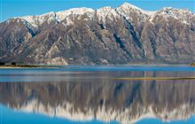
This block includes the Dingle Burn catchment except for near the mouth where the valley opens out around Dingle Burn Station. It also includes some of the faces overlooking Lake Hawea and run parallel and to the west of the Dingle Burn Valley.
Lower and mid valley, the vegetation is mostly dry mountain beech/tamauka, with more grassy flats and tussockland in the upper valley. Below Cotters Hut, there are a few slips, gullies and river crossings to negotiate; above here travel is easier. The lake faces west of the Dingle are predominantly tussock with some areas of beech/tawhai and mānuka/kānuka forest lower down.
During the roar period in the months of March and April, the block divides into four separately balloted portions. Mount Jones covering the lake faces, and three roughly equal portions of the Dingle Burn Valley itself – Lower Dingle, Cotters and Upper Dingle.
Access
There are four access routes depending on which part of the block you are hunting:
- For the lake faces (Mount Jones), take Gladstone Road from Hawea township and then Dingle Burn Station Road for 14 km to a car park – no vehicle access permitted beyond this point. From here follow the track (you may carry unloaded firearms) to Turihuka Conservation Area (3–4 hours) where there is a campsite. Continue on the Lake Hawea Track by the lake to the hunting block, about 5 km away.
- For the lower Dingle, as above to Turihuka Conservation Area and then follow the Dingle Burn Valley Track.
- You can access the Cotters block from the lower Dingle, or fly into the airstrip near Cotters Hut.
- For the upper Dingle, as above, or alternatively, cross from Ahuriri Conservation Park near Ahuriri Base Hut.
Landholders
Dingle Burn Station
Maps
NZTopo50 series: BZ13, BZ14, CA13, CA14
- Mount Jones hunting block map (PDF, 1236K)
- Lower Dingle hunting block map (PDF, 1463K)
- Cotters hunting block map (PDF, 2189K)
- Upper Dingle hunting block map (PDF, 2140K)
Huts
- Bush Hut
- Cotters Hut
- Ben Avon Hut – historic hut, day use only
- Top Dingle Hut
Know before you go
Dogs
Dogs are allowed in the Lower and Upper Dingle Burn and Cotters blocks, no permit or permission required but entry/exit for these blocks is either through the Upper Dingle from the Ahuriri side or via helicopter.
Dogs are allowed in the Mt Jones block, no permit or permission required but access is only via boat or helicopter.
Help control wallabies in this area by reporting sightings
Wallabies can displace other species, affect pastures and native species' habitats.
They also potentially impact production and native ecosystems.
Report your sighting online – it only takes a few minutes.
You can also report wallaby sightings by calling 0800 80 99 66.
Contacts
| Tititea/Mount Aspiring National Park Visitor Centre | |
|---|---|
| Phone | +64 3 443 7660 |
| wanakavc@doc.govt.nz | |
| Address | 1 Ballantyne Road Wanaka 9305 |
| Hours | See visitor centre hours |