
Located in Tongariro National Park in the Central North Island region
Introduction
Trek across a volcanic alpine landscape of dramatic contrasts. From May to October, alpine skills are essential for this track – it's best to go with a guide.- Fitness required: High
- Gradient: Steep and undulating
20.2 km one way
Walking and tramping
Seasonal restrictions
Labour weekend (late October) - 30 April
Parking restrictions (4 hr maximum) are in place at the road-ends – we suggest you book a shuttle. Intermediate track category.
May - October (winter season)
Additional hazards are present including snow and ice, avalanche risk, and sub-zero temperatures. Expert route category.
Dog access
Image gallery
Video
May to late October – winter season
Special skills and preparation are required to complete the Tongariro Alpine Crossing in winter. There is increased risk from snow, ice, avalanche terrain and sub-zero temperatures.
Trek across volcanic alpine landscape of dramatic contrasts – steaming vents, glacial valleys, ancient lava flows, alpine vegetation and vivid crater lakes, all with stunning views.
Bookings are recommended for all visitors using any part of the Tongariro Alpine Crossing track. A track booking is needed to use a shuttle or guided walk service.
Book to use any part of the Tongariro Alpine Crossing.
About the track
This challenging trip begins at 1120 m following a well-formed boardwalk in a gradual climb through the Mangatepōpō Valley. The initial 5.4 kilometres share the track with the Soda Springs Walk. Soda Springs Walk is an easy 2 hr return is a good option for those who may not have the fitness to attempt the more challenging parts of the crossing.
At the end of the valley the track increases in difficulty, with a steady climb of around 350 m up a staircase to a short plateau in South Crater.
The climb resumes with the ascent to Red Crater, the highest point in the Crossing at 1886 m.
A steep descent on volcanic rock scree brings walkers to the vivid Ngā Rotopounamu-Emerald Lakes.
Loose rocks and stones on the steep slopes of Red Crater present a major slip hazard. Walkers are advised to take extra time and care.
The track continues past Blue Lake - Te Wai Whakaata o Te Rangihīroa (Rangihīroa’s mirror) and begins the long descent of the Northern slopes. The zig-zag descent includes many steps which can present difficulties for those with weaker knees.
Enjoy the magnificent views over Lake Rotoaira and Lake Taupō before descending further into lush forest. The track ends at Ketetahi Road at an altitude of 760 m.
Be prepared for a long and challenging day out and be rewarded with stunning vistas and experiences.
Elevation profile
- Change in elevation: +/- 1196 m

Alternative walks
If conditions are poor, try alternatives such as Taranaki Falls Walking Track or Tama Lakes Track.
Understand if you are ready for the Tongariro Alpine Crossing
Watch the NZ Mountain Safety Council’s walk-through video which takes you through how to prepare for this track. Including facilities, key decision points, hazards and typical conditions for the area.
Bookings are recommended for all visitors using any part of the Tongariro Alpine Crossing track. Bookings are needed to use a shuttle or guided walk service.
There is no cost to book.
The nearest towns are:
- Whakapapa (10.4 km)
- National Park (13.5 km)
- Tūrangi (36.7 km)
- Raetihi (47.6 km)
- Ohakune (48 km)
- Taumarunui (61.5 km)
- Taupō (86.5 km)
During the summer there is no parking for visitors doing the Tongariro Alpine Crossing at Mangatepopo car park. There is a private carpark near the end of the hike at Ketetahi. The best way to get to the Tongariro Alpine Crossing is by shuttle.
Shuttle services run from all local towns – arrange through the following isites and information centres:
- Ohakune isite 0800 647 483, 54 Clyde Street, Ohakune
- Taumarunui isite +64 7 895 7494, Railway Station, Taumarunui
- Tūrangi Customer and Visitor Information Centre 0800 288 726, Ngawaka Place, Tūrangi
- Taupō Customer and Visitor Information Centre 0800 525 382, 30 Tongariro Street, Taupō
Note: We expect a significant increase in traffic on State Highway 46 (near Ketetahi Road) this summer. We recommend visitors to the Tongariro Alpine Crossing park in local towns and organise their shuttle to and from safe locations.
May to late October – winter season
You need special skills and preparation to complete the Tongariro Alpine Crossing in winter. There is increased risk from additional hazards – snow, ice, avalanche terrain and sub-zero temperatures.
The track is not suitable for all walkers
Most of the track is open, difficult, exposed and on uneven surfaces.
This track is not recommended for children under the age of 10. The track travels over exposed mountainous landscapes and often with adverse weather conditions.
Alpine weather
The track passes through an alpine environment with changeable weather conditions at all times of year. It is common to experience very cold temperatures, strong wind, heavy rainfall and poor visibility in summer – snow can fall at any time of year.
Check the weather forecast – NIWA website before you go.
Volcanic risk
The Tongariro Alpine Crossing passes through volcanic hazard zones – even when the track is open, volcanic risk is present. Volcanic monitoring systems monitor activity and mitigate volcanic risk, but won't ensure your personal safety. If you are uncomfortable with this risk, choose a different track.
Te Maari, Red Crater and Ngāuruhoe vents have all been active within the last 100 years – the most recent eruption occurred from Te Maari in 2012.
Before you go:
- know the volcanic risks and what to do in an eruption, and
- check volcanic activity information on the Geonet website.
Geothermal hazards
There is geothermal activity around the Tongariro Alpine Crossing – especially near emerald lakes. Steam vents (fumaroles) should not be approached – steam is very hot, the ground can be unstable and severe burns are possible. Stay on the marked track at all times to avoid injury.
Hazardous weather advisory
During the summer hiking season, a ‘Not Recommended Today’ advisory is applied to the Tongariro Alpine Crossing when the weather is potentially hazardous.
The advisory is applied if any of the following parameters are exceeded on any two hours between 9 am and 5 pm on the NIWA Tongariro Alpine Crossing (Red Crater) weather forecast:
- average wind speed of 55 kph or greater
- wind gusts of 70 kph or greater
- wind chill of minus 10 °C or colder
- wind chill of 0 °C or colder with 1 mm of precipitation or greater
- rain rate greater or equal to 2.5 mm/hr
- snow rate greater or equal to 0.1 cm/hr
and/or:
- precipitation of 10 mm or greater as a six-hour accumulation between 9 am and 5 pm.
The assessment to apply the advisory will be made at 6 am every day. If applied:
- signage is placed at Mangatepōpō Road end
- an alert is automatically placed on the weather forecast – NIWA website
- transport and guiding operators, isites and visitor centres will be advised automatically via email.
There are no hazardous weather advisories issued from May to October, so you will need to read the forecast carefully and consider whether you have the skills, experience and equipment for the conditions.
Amenities
Toilets are every 1–2 hr along the track.
Tongariro – a World Hertiage site for its cultural values
The Tongariro Alpine Crossing winds through mountains sacred to Ngāti Hikairo ki Tongariro of Ngāti Tūwharetoa. Every step is an opportunity to connect with the essence of the land and ultimately contribute towards its care. Honour the requests of Ngāti Hikairo by staying safe and respecting their home.
Booking system
You need a track booking for shuttle and guided walk services. Bookings are recommended for all visitors using any part of the Tongariro Alpine Crossing track.
Book to use any part of the Tongariro Alpine Crossing.
Read about why a booking is recommended and sustainable visitor management for Tongariro.
School groups
School groups are encouraged to use the booking system. Those requiring further assistance with trip planning are encouraged to contact the Tongariro National Park Visitor Centre.

No mountain biking
Mountain biking is not allowed on this track.
 No unauthorised drone use in the national park
Unauthorised use of drones is prohibited. You must have a permit to fly a drone.
DOC does not generally approve permits to fly drones in this national park and we do not recommend you apply for one.
In addition to the Day Hikes gear list, take:
- 2 to 3 litres of water – water along the track is not suitable for drinking.
Check know before you go for the gear list in winter months.
How to pack for a day walk
May to October – winter season
Track standard: Route
Track surface: Track is covered in snow and very icy in sections.
Suitable for: People with alpine skills, equipment and experience. You must:
- know how to navigate if cloud or snow covers the marker poles and you cannot see them
- know where avalanches are a risk and be able to rescue someone if an avalanche occurs
- have the equipment and skills to prevent a slide on icy terrain
- have the clothing for sub-zero temperatures and be able to survive if the weather gets worse.
Prepare for a long, challenging day

Allow 9 hours to complete the walk. There are between 9 and 11 hours of daylight in winter, so leave early enough to complete the trip before it gets dark. Always take a head torch.
Be prepared to turn back if conditions are no longer safe or if your progress is too slow.
Dress for cold, windy and icy conditions
On a calm day, Red Crater is at least 10°C colder than Taupō and 5°C colder than the start of the track – subtract another 2°C for every 10 km/h of wind:
Eg, when it’s 10°C (50°F) in Taupō, a calm day at Red Crater will be about 2°C (35°F). This feels more like -2°C (28°F) with moderate winds of 20 km/h (11 knots).
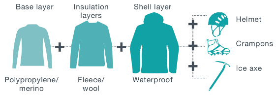
Conditions can change quickly. Layer your clothes to trap warm air in and keep cold wind out. Start with a base layer of polypropylene/merino, add an insulation layer of fleece/wool and finish with a waterproof shell layer.
Expect ice on the track between April and October. A helmet, crampons and ice axe are essential, as is competency using them. 38% of tramping injuries are from slipping.
Be avalanche alert
Avalanches are a hazard. Know the avalanche forecast. Take an avalanche transceiver, avalanche probe and snow shovel, and be competent using them.

Take these essentials
- Plenty of drinking water (water along the track is not suitable for drinking), food and toilet paper
- Waterproof jacket and pants, hat, gloves, sunscreen, and warm, layered clothing
- Sturdy tramping or mountaineering boots
- Crampons, ice axe and helmet
- Avalanche transceiver, avalanche probe and snow shovel
- Mobile phone, personal locator beacon (PLB), head torch and spare batteries
- Map, compass and/or GPS
Make a plan
Talk with someone at the Tongariro National Park Visitor Centre who knows the current conditions.
Check the latest:
- avalanche forecast – New Zealand Avalanche Advisory website
- volcanic alert level – GeoNet website
- weather forecast – NIWA website
Know the route – deep snow can hide track markers.
Shuttle buses generally don't operate during winter, but guided trips include transport.
Go with a guide
Know your limits. Have a memorable and safe experience with Tongariro Alpine Crossing guiding companies.
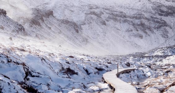
Mangatepopo Valley in winter
Image: Zhi Yuen Yap ©
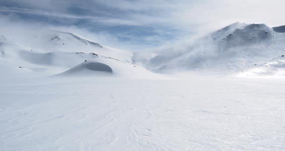
South Crater in winter
Image: Zhi Yuen Yap ©
Nature and conservation
This is the perfect habitat for a variety of New Zealand’s native birds. In forested areas, you may see bellbird/korimak, tūī, New Zealand robin/toutouwai, tomtit/miromiro, fantail/pīwakawaka and maybe New Zealand's smallest bird the rifleman/titipounamu. Part of the shuttle fee of about $40 helps DOC with conservation projects.
History and culture
All waterways including the lakes on Tongariro and his peaks Ngauruhoe and Ruapehu are sacred to local iwi, Ngāti Hikairo ki Tongariro of Ngāti Tūwharetoa.
Kaumātua Te Ngaehe Wanikau asks visitors to the area to respect the sanctity of the maunga tapu (sacred mountains) by not touching or entering any of the waterways including the alpine lakes.
Ngāti Hikairo ki Tongariro places extreme importance on their guardian role in protecting Tongariro and his peaks.
Ngatoroirangi, the founding ancestor of Ngāti Tuwharetoa, the local iwi (Māori tribe), ascended the great mountains of the Central Plateau 30 generations ago. It was then that he named Tongariro and the many features of the surrounding landscape, declaring this area as home for his descendants. It is from these beginnings that Ngāti Tuwharetoa maintains its intrinsic responsibility to protect the mountainous area to which they belong.
The generosity and foresight of Ngāti Tuwharetoa saw the heart of the mountainous area made sacrosanct in 1887, with the intent that the Crown would stand alongside Ngāti Tuwharetoa to ensure the continued protection of Tongariro. This led to the establishment of the Tongariro National Park in 1894, a first for New Zealand, and fourth in the world.
In 1993, Tongariro became the first property to be inscribed on the World Heritage List under the revised criteria describing cultural landscapes. The mountains at the heart of the park have cultural and spiritual significance to Ngāti Tuwharetoa and symbolise the spiritual links between this community and its environment. The park has active and extinct volcanoes, a diverse range of ecosystems and some remarkable landscapes.
The continued occupation by Ngāti Tuwharetoa in this environment ensures the cultural, spiritual and environmental values are protected and shared with all those who encounter this dynamic landscape.
Stay safe in the outdoors
- Choose the right trip for you. Learn about the route and make sure you have the skills for it.
- Understand the weather. Check weather forecasts.
- Pack warm clothes and extra food. Check gear lists.
- Share your plans and take ways to get help. Share directly or use the Outdoor Intentions form or Plan My Walk. Take a distress beacon.
- Take care of yourself and each other.
