Introduction
Kapiti has rich Māori and colonial heritage. On the island you'll find The Whare - the oldest building on Kapiti Island, and the oldest building associated with nature conservation in New Zealand.Kapiti Island is the summit of a submerged mountain range created by earthquakes 200 million years ago.
At one time, moa and kakapo wandered the valley that lay between the mountains to the rest of the mainland. Several million years ago, most of this range was inundated by rising sea level. It was, for a time, part of a land bridge that extended across what is now Cook Strait. What remains is an island about 10 km long and 2 km wide of wind-blasted hillsides to the west and lush temperate rain forests to the sheltered east.
Tikanga Māori
Ko te Waewae Kapiti o Tara Raua ko Rangitane: the full name given by Māori to Kapiti describes the island as the meeting place of the boundaries of Tara and Rangitane. Tara and Rangitane were the son and grandson of Whatonga who, in 1150 AD, divided the country by making a boundary from the southern tip of Kapiti Island straight across to the east coast of the North Island.
The land to the south he gave to Tara and the land to the north he gave to Tautoki, another son whose heir was Rangitane.
The waters between Kapiti Island and the mainland were once travelled by the waka of the Rangitane people, the Muaupoko and later those of Te Rauparaha of Ngati Toa who gained dominance over Kapiti by 1823.
This stretch of sea is called Rauoterangi Channel to commemorate the swimming feat of Kahe Te Rauoterangi, daughter of a Ngati Toa chief. Persuaded by a dream, she set out from Kapiti with her daughter strapped to her back, to warn allies on the mainland of a threatened attack. Te Rauoterangi was carried by the current to Te Uruhi, south of the Waikanae River and about 11 km from the starting point. The child survived the crossing but died not long afterwards.
Known as “motu rongonui” or “famous island” to pre-European Māori, a succession of tribes have used Kapiti. Settlements occurred on much of the eastern side, including Rangatira Point. Kapiti was the stronghold of the famous Te Rauparaha and a strategic location for Māori military activity as late as the 1830s. By this time, however, the island was shared with European whalers.
Colonial history
During the 1840s, much of the land was cleared for farming and sheep, goats, pigs, deer, cats, and dogs were introduced. Whales declined precipitously, and the island was given over to farming after about 1850. Today, DOC preserves many artefacts from the whaling period, such as the “trypots”, used for boiling down blubber, that can be seen on shore.
The Whare
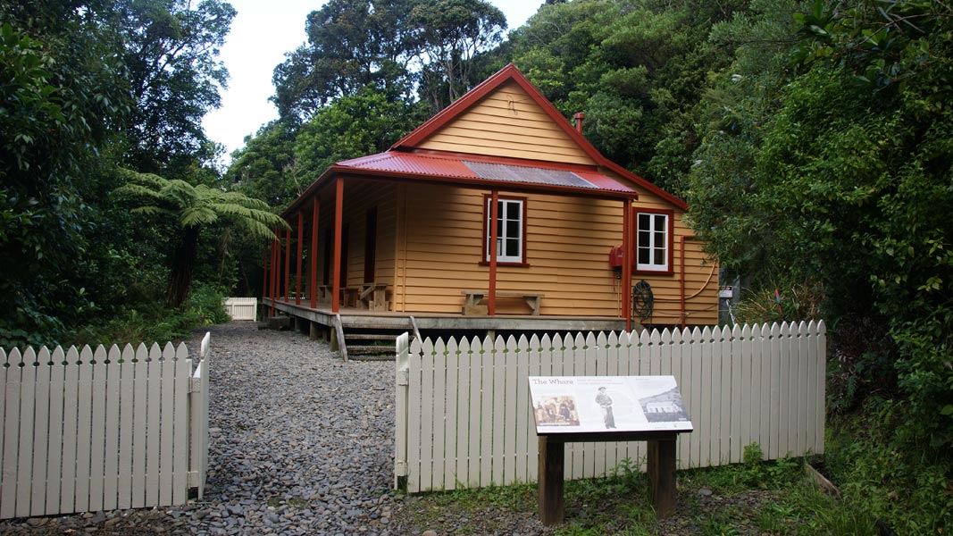
The Whare is the oldest building on Kapiti Island and the oldest building associated with nature conservation in the country.
It is thought to originate from the early 1860s when it was built as the homestead for the McLean family who farmed the island at the time.
In 1897 much of the island was purchased by the Government for the purpose of protecting its natural heritage.
The Whare became home to a number of island caretakers including Richard Henry, the world’s first state sponsored conservation officer. He was appointed to Kapiti Island in 1908 after serving on Resolution Island where he pioneered much of his work on capture techniques and successful species relocation methods. He lived in the Whare for three years before his retirement.
By 1924 another caretakers cottage was built. Since then the Whare has been used as a base for scientists, trappers, students and numerous dignitaries and visitors.
A simple rectangular timber framed building with gabled roof. There are three rooms, the two southern most used as bedrooms and the northern most a kitchen and living room. A lean-to is located on the western elevation for the ablutions block and a veranda runs round the eastern and northern elevations. Exterior walls are clad in shiplap weather-boards while the roof is corrugated steel.