Located in the Bay of Plenty and East Coast regions
Introduction
The Whirinaki - majestic, primeval, ancient - stands shoulder-to-shoulder with the great forests of the world.Be awestruck, walk in gentle silence or ride through the mists of this primordial place.
Feel the breath of life, the song of Tāne, transcend time, walk in the footsteps of dinosaurs, in the shadow of giants, be welcomed and embraced by the Whirinaki.
Whirinaki Te Pua-a-Tāne Conservation Park is 90 km southeast of Rotorua, off Te Whaiti Rd, via SH38. The most popular entrance to the park is past Minginui village and up River Road to the River Road car park, the starting point for many walks.
Mangamate Campsite
This campsite is managed by Te Rūnanga o Ngāti Whare.
In October 2024, significant work was carried out at Mangamate campsite and it is now in a condition to be opened to the public.
For overnight campers, a gate will be installed at the entrance to the Mangamate access road, close to the main road intersection, that will be locked late each night and reopened early each morning.
For campsite enquiries or updates visit the Te Rūnanga o Ngāti Whare website.
Flood safety
River levels rise under heavy rain in a matter of hours causing tracks to washout, which occur regularly from April to August. The end of Okahu road to the Rogers Hut track is particularly known to flood at these times. Check forecasts to effectively plan your visit.
Weather
The weather in the park can be very unpredictable and visitors should be prepared for cold, wet spells even in summer. Frosts and snow are also likely on high ground throughout the year. High rainfall causes rivers in the area to rise very quickly although they usually fall rapidly once the rain stops. You need to be well prepared for tramping and walking in the park.

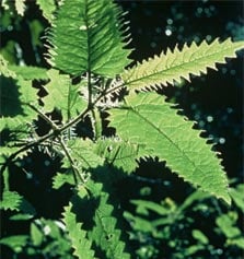
Be careful of stinging nettle/onaonga
Image: G Woodward
Hut passes
Hut passes are no longer available at the Murupara office. If you require hut passes or tickets contact the Opotiki iSite +64 7 315 3031 or the Rotorua iSite +64 7 348 5179.
Maps
The relevant maps are NZTopo50 series: BG38 Wairapukao, BG39 Ruatahuna, BH38 Te Haroto, and BH39 Putorino.
Stinging nettle/ongaonga
Ongaonga or stinging nettle are present. This can have a painful sting, which may last several days.
Motorcycles
DOC and contractors use motorcycles to complete high priority work in this area. Tracks used include Moerangi Track, Rogers Hut to Mangakahika Hut and River road car park to Central Whirinaki Hut. If motorcycles are active in the area, it's likely DOC staff or contractors are at work so take care.
The power of the trees
Whirinaki is best known for its awe-inspiring trees. The greatest of these are known as podocarps and include rimu, tōtara, kahikatea, mataī and miro.
These forest giants have always been valued but in quite different ways now compared to the past. Visitors who marvel at their great height and size are often surprised to learn that logging of this forest ceased as recently as the mid-1980s.
Conservation groups actively campaigned to stop the native harvest and came into direct conflict with the local community who saw this as a threat to their lifestyle and employment.
In 1985 a new government ended the logging of native trees and by 1987 all logging of native timber had stopped at Whirinaki.
Plants and animals
The vegetation of Whirinaki changes from lowland podocarp forest in the basins through to beech forest in higher altitude areas. The plant life reflects the landform, altitude and soils along with past disturbance by volcanic activity and burning by humans. The park’s most striking characteristic is its wonderful podocarp forest.
Birdlife is diverse and abundant. The forest supports high numbers of rare birds such as North Island brown kiwi, red and yellow-crowned kākāriki, and North Island kākā. Other notable birds include whio (blue duck) and the endangered kārearea (New Zealand falcon).
New Zealand’s only native land mammals, long-tailed and short-tailed bats (pekapeka), are present but rarely seen. Alert visitors may catch sight of a long-tailed bat around the forest edges in the evening.
Many introduced mammals have also made Whirinaki home. These include red deer, pigs and possums which have played a major part in modifying the forest. Deer and possums were liberated in the late 1890s and their populations rose to a peak around the late 1950s. Rats, mice, cats and stoats are also present.
The lie of the land
Whirinaki is located between the central volcanic plateau and mountain axis of the North Island. To the west is the Kaingaroa plateau, while to the east and south are the Huiarau and Ikawhenua ranges, bounded by the Whaeo and Te Whaiti faults.
The park contains elements of volcanic and non-volcanic landforms and soils, and the plant and animal life reflects these differences.
The land is still and peaceful now but this belies the violent origins of the Kaingaroa Plateau and Whirinaki basin. About 1800 years ago the Taupo eruption ejected a great wave of pumice, destroying all in its path and creating a new landscape. A lot of material also fell from the air, cloaking the greywacke ridges to the east.
The northern part of the forest, west of the Whirinaki River, is relatively low country which rises from 360 m to 730 m. There are beautiful river flats and rolling, tree-covered hills and gullies. These are a marked contrast to the steep rugged greywacke country in the south which rises to 1365 m at Maungataniwha.
Whio
The story of Whirinaki whio is as old as the trees which the Whirinaki Forest is famous for. Read about whio in Whirinaki te Pua a Tāne Conservation Park.
Māori have lived here probably as long as the oldest trees still standing. The original inhabitants of the Whirinaki valley were believed to have been Te Marangaranga. They were conquered by Wharepakau and his nephew Tangiharuru, descendants of Toi the great Māori chief.
Through this conquest Wharepakau and Tangiharuru, with their people, occupied the lands in the Whirinaki and Rangitaiki valleys and their descendants have lived in the district ever since. Ngāti Whare are descendents of Wharepakau and regard themselves as the guardians of Whirinaki Te Pua-a-Tāne Conservation Park.
Māori association with the forest is also spiritual. Whirinaki protects and preserves the people and legends of the past, is traditionally known as a pātaka kai (source of food), and provides herbs and building materials for cultural purposes. These include tōtara for meeting houses and other carving work.
Ngāti Whare
The history of Māori iwi Ngāti Whare is written on the hills, valleys, and trees of the Whirinaki.
Ko au ko te Whirinaki, ko te Whirinaki ko au. I am the Whirinaki, and the Whirinaki is me.

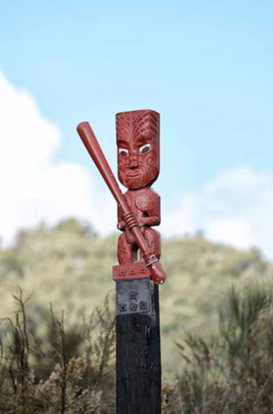
Te Whaiti pou
Image: Neil Hutton ©
Relationship with the forest
From the time their ancestor Wharepakau Tao-Tao-Ki-Te-Kapua (from whom Ngāti Whare take their name) migrated south to the Whirinaki area, Ngāti -Whare have lived in close relationship with the Whirinaki Forest.
As forest dwellers, the people of Ngāti Whare were dependent on the rich food resources of the forest. Fern root was a staple food product and was cultivated in clearings created in the forest and maintained by fire and shifting cultivations. Many other forest plants were used for rongoā (medicine).
Birds were plentiful and held in high esteem. The taking of birds was strictly controlled and rāhui (prohibition) would occasionally be put on sections of forest to allow bird populations to recover.
The forest also provided many other necessities: wood for shelters, waka, weapons, fortifications, and carvings; bark for household vessels and roofing; vines for lashing and hīnaki (eel pots); and feathers for clothing.
Ngāti Whare and Whirinaki today
Today, Ngāti Whare's kaitiakitanga (guardianship) of the forest is officially recognised and they co-govern the park with DOC.
Ngāti Whare has established a native nursery in the Minginui village and has long-term plans to restore hundreds of hectares of land neighbouring the Whirinaki back into native forests. Minginui, once home to sawmills that processed thousands of native logs, is now home to a nursery that will restore the native forests lost to logging.