Department of Conservation | Te Papa Atawhai
https://www.doc.govt.nz/
https://www.doc.govt.nz/
Introduction
Satellite images can show where suspended sediment is present in the sea around the coast of New Zealand.This report details the use of existing satellite (also called remote sensing) imagery to date and presents opportunities to extend its use for sediment monitoring.
Download the report
Monitoring coastal suspended sediment in Aotearoa New Zealand: utility of satellite remote sensing. (PDF, 8,120K)
Pinkerton, M., Gall, M., O'Callaghan, J., Thoral, F. and Swales, A., 2022.
About the report
A national-scale assessment of long-term trends (2002 – present) in satellite-observed total suspended particulate material, and preliminary interpretation of regional patterns, is included in the report.
Recommendations to improve the value of satellite remote sensing are given and summarized below. Feedback from three stakeholder engagement workshops were used to guide these recommendations.
Objectives
The present research project has various objectives.
- To assess national satellite images for trends in coastal sedimentation and identify places with major changes either positive or negative.
- To assess how tools (technology, and instrumentation) can add value to coastal sediment management at both a national level and local level.
- To assess how the tools can be used in conjunction with each other and existing datasets.
- To provide recommendations for improvements of Seas, Coasts and Estuaries New Zealand (SCENZ) and other tools.
Interactive satellite image tool
NIWA-SCENZ: Seas, Coasts, Estuaries New Zealand
Current uses and limitation of satellite data
Satellite data is currently used to monitor events such as algal blooms and oil spills, as well as water temperature.
Its usefulness for understanding and monitoring suspended sediment depends on having a good match between the on the ground sensor technology and remote sensing science, and the variation in sediment with space and time. If not a good match, sediment may not be visible by remote sensing because of low resolution imagery or not frequent enough observations.
Satellite data can be used to monitor the concentration of total suspended solids (TSS) at broad time (months–decades) and space scales (500 m–national scale).
Although sediment is often the main driver of changes to water clarity in coastal New Zealand, coloured dissolved organic matter (leached from decaying plant material in soils) and local growth of phytoplankton can also contribute to TSS. Satellite data generally cannot definitively say where the coastal TSS came from (such as terrestrial via rivers, coastal erosion or resuspension of seabed material).
Sedimentation, and suspended sediment, tends to be greatest after storms when floods carry sediment downstream, and when powerful waves erode the coast and resuspend sediment from the seabed. During calm weather there may be little visible sediment.
Appreciating this variability is crucial when monitoring for change, and for understanding what satellite observations can and cannot provide in the context of monitoring and improved understanding. The value of satellite technology is also improving all the time.
Techniques used
Techniques used include underwater cameras, buoys, automated river monitoring, vessel-based sampling and remote sensing ocean colour data (suspended sediment gives water a distinctive brightness and colour that can be detected from space).
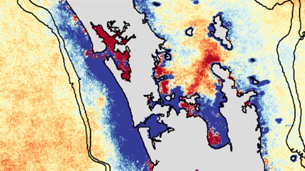
Trends in total suspended solids 2002–2020
The aim of this part of the work is to use the satellite data to identify the key places of change, over 18 years, in suspended sediment (including concentration and water clarity), and to begin to relate these changes to their physical characteristics; eg river mouths and other coastal areas, and exposed versus sheltered locations.
An analysis of the TSS trends in at a national scale are presented in the report. Places with large changes are identified.
Long-term linear trends in TSS were presented with seasonality removed. In general, the greatest increasing trends in TSS concentrations (> 0.3 %) are seen around coastal regions of the South Island, while most of the North Island has decreasing trends (< 0.3%). Some of these changes are likely to be related to changes in phytoplankton-derived particulates and/or oceanographic and climate process which influence coastal erosion and resuspension of sediment rather than sediment from catchments. The relative contributions of each to the TSS can be teased out using finer scale imagery and on the ground studies.
Patterns of long-term change in TSS close to some estuary mouths (both increasing and decreasing) strongly suggest changes to terrestrial (riverine) input of sediment to the coastal zone are responsible.
Recommendations for next steps
Make more use of new satellite capability: Satellite remote sensing is recognised globally as a crucial component in monitoring water quality and productivity in coastal waters. Scientists and managers should actively seek new applications of satellite data while developing an awareness of limitations.
Use national scale satellite data to prioritise in situ efforts: Satellite data should be used with other sources of information to monitor change, help anticipate future changes and prioritise management/research efforts. The best insights and environmental management will be achieved by using multiple methods together.