Image: Pete Brady | ©
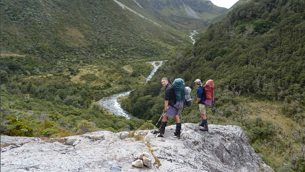
Minchin Stream towards Minchin Pass.
Minchin Pass Route

Located in Arthur's Pass National Park in the Canterbury region

This route travels the eastern and northern flanks of Arthur's Pass National Park. The sections through the upper Minchin Stream and Townsend Creek are more adventurous.

Note: True right and true left refers to the sides of the valley when looking downstream.

Andrews Shelter to Casey Hut or Trust-Poulter Hut

Time: 6 - 8 hr

Andrews Track

Just upstream of the bridge near Andrews Shelter, a marked track begins on the true left and climbs steeply through open scrub to the beech forests above. It continues to climb but then meanders across regular side creeks, while generally keeping much to the same contour. Eventually it re-joins Andrews Stream at Hallelujah Flat (about 2 hr 30 min from the shelter).

From the start of Hallelujah Flat, follow the grassy flats over Casey Saddle. Old sections of the track in the forest on the eastern bank are now obstructed by wind-throw, and it is far better to stick to the open country. Parties travelling in the opposite direction should look for the track leaving Hallelujah Flat a little below the side-creek on the true left. This gives a view right up the creek bed to the scree and ridge-crest beyond, and is about 10 minutes downstream from the last clear view back up Hallelujah Flat to Casey Saddle. For the first 10 minutes the track keeps within a few metres of the stream bank; then it climbs into the beech forest.

Casey Track

Beyond the saddle, keep to the terrace immediately above Surprise Stream. After a few minutes, the reasonably well-worn track crossing the saddle drops into the streambed below a small swamp. The forest track to the Casey Hut site begins a few minutes below Trinity Stream–Surprise Stream–Pampas Stream confluence. The track marker is tucked under the forest canopy on the true right, just past a bit of rough track through scrub on that side.

About 50 m downstream from the marker on the opposite side, a steep eroded gravel bank drops into the stream. If you get as far as this almost treeless bank, then you have overshot the track. From the stream the track climbs a little, sidles then descends down a ridge to emerge from the bush on a large grass flat near Casey Stream.

The original Casey Hut site is back from the stream at the bush edge, midway down the flat. From this site, continue another kilometre along the Casey Stream bed to the Poulter River flats to reach the new Casey Hut.

Trust-Poulter Hut

At the old hut site instead of taking the track to the new Casey Hut, take the track north across the Casey River (note this river can rise quickly) to follow another 4WD track across river flats for another 1 hour 30 min to reach the Trust/Poulter Hut.

Mountain bikers are permitted on the section of route from the old Casey Hut site (having cycled up the Poulter), as far as the Trust/Poulter Hut.

Trust/Poulter Hut to Poulter Hut

Time: 1 hr

Beyond here the vehicle track turns the corner and fades out. Continue on the true right of the Poulter for a few minutes, then head diagonally across the riverbed to a point about half a kilometre below the outlet of Minchin Stream, on the true left. Follow the marker poles through high matagouri shrubs to the start of the track to Lake Minchin and Poulter Hut. The hut is on the bush edge, on the true left bank of the Poulter River.

Poulter Hut to Lake Minchin

Time: 1 hr

A further hour of well-marked track leads to the old hut site at Lake Minchin – pleasant walking on easy gradients through beech forest. With light packs it makes a pleasant day excursion. The northern end of the lake is best for camping as there are now no huts by the lake.

Lake Minchin to Minchin Pass

Time: 3 hr

Follow the well-formed track around the eastern side of the lake, and travel up the river flats for about half an hour.

A track marked by a large orange triangle begins on the true right, just beyond the broad shingle fan of a side creek opposite – a few minutes before the river narrows to an impassable gorge. This track bypasses the gorge, climbs high to rocky outcrops above precipitous bluffs, and then drops steeply through bush to rejoin Minchin Stream at its junction with Linwood Creek.

Above the gorge the route follows Minchin Stream, constantly crossing and re-crossing to the next significant junction about 1 km upstream. Minchin Bivvy stands a little above the river in the ‘V’ of this junction. Minchin Pass is an hour further on from the bivvy. Above the bivvy, the track continues on the true right through scrub and across a flat tussock terrace, before climbing to the left to the low tussock saddle of Minchin Pass.

Warning: This area is subject to avalanche activity during the winter. We advise visitors not to travel this route during heavy snow conditions.

Minchin Pass to Taramakau River

Time: 3–5 hr (depending on your boulder-hopping skills)

Descend into Townsend Creek along the marked route. Once in the creek bed it is difficult to get out again through the thick scrub, so you will need to boulder-hop. The large boulders and low waterfalls make travel slow and difficult.

About 1 hr from Minchin Pass, look for markers on the left to a small (approx 300 m) bypass to avoid a waterfall. Once past this the route drops back to Townsend Creek. Follow the creek to a confluence with two creeks on the true left and true right. Make sure you stay in the middle creek.

If travelling up Townsend Creek from Taramakau River, be careful not to miss the route at this junction. Here Townsend Creek becomes a secondary side-creek and seems to disappear under low bush cover, while the main stream continues up a more open course towards Koeti Pass. The point is easy to recognise by a third small creek dropping in from the west – making Townsend Creek the middle one of the three.

Beyond this confluence, travel down a steep, open creek bed; this narrows to a tight gorge where bluffs and bush hang closely overhead. The creek continues its steep descent but the gorge is fairly easy to travel when the stream is low. When the stream is high it becomes impassable.

Below the gorge the stream swings west, then north to join the Taramakau, descending more gently from the mouth of the gorge to an open L-shaped stretch of streambed. If travelling up Townsend Creek you can verify you are on the right route – the first 15 min to the gorge is in a broad open bed, turning east at right angles a few minutes up from the Taramakau.

Warning: Travel in Townsend Creek can be difficult, particularly for less-experienced trampers. The trip could take longer than 3 hr, and should not be attempted after heavy rain.

Townsend Creek to Otira River

Time: 4–5 hr (route only)

From where Townsend Creek enters the Taramakau River, it is about 1 hr either upstream to Locke Stream Hut or downstream to Kiwi Hut.

To reach Locke Stream Hut, travel on river flats on the true right of the Taramakau River to Locke Stream. About 50 m up Locke Stream on the true right, a short bush track leads to the hut. Refer to Harper Pass Route for the trip over Harper Pass from here.

To go to Kiwi Hut, travel down the Taramakau River, taking advantage of stable, grassy flats by crossing and re-crossing the river where necessary. Kiwi Hut is on the true right of the Taramakau, about 1 hr below Townsend Creek. A signposted track leads from the riverbed into the bush for 100 m and across a large clearing. The hut stands in bush on the terrace at the far side of the clearing.

From Kiwi Hut, continue following the Taramakau River downstream, picking the best places to cross. Below Pfeifer Creek on the true left of the Taramakau, markers lead the way across the grassy flats to pick up a track through gorse and shrubland. The track ends at the Otira River.

Note: The shelter marked on some maps and publications has been removed.

Select the best place to cross the Otira River, aiming for the big orange triangle that indicates the track across farmland to SH73.

If the Otira River is too high to cross, back-track to the flood track that travels up the true right of the river to the Morrison footbridge at the confluence of the Otira and Deception Rivers. This is a marked track but is not well maintained. It will take 3–4 hours to reach the footbridge. In extreme weather conditions, this route can also be cut off by flooded sections.

Parties travelling from North to South should not use the emergency flood track to start their tramp. If the Otira river is not crossable, the Taramakau river and Townsend Creek will not be crossable.

The track starts at Andrews Shelter on Mount White Road, which turns off SH73, 24 km east of Arthur’s Pass. The western end is at the Taramakau River valley, which meets Otira River at Aickens beside SH73, 25 km west of Arthur’s Pass. There are limited options to leave a vehicle here. Shuttle buses run between Christchurch and Greymouth each day.

What to expect

  • Travel to the old Casey Hut site is possible without having to ford a major stream; after that there are several crossings that may become impassable if rivers are up.
  • The sections through upper Minchin Stream and Townsend Creek are significantly more difficult. In particular, the gorge of Townsend Creek is impassable when the creek is running high, as descent through the bush is not possible on either side.
  • Hazards: Flooded rivers, avalanche, unmarked route.

Be prepared

  • Experience: Suitable for fit, well-equipped and experienced backcountry trampers only.
  • Best season: Summer and autumn.
  • Maps: NZTopo50 - Moana BU20, Haupiri BU21, Cass BV21.
  • Before setting out, check the latest track conditions and avalanche advisory with the Arthur's Pass Visitor Centre.
  • Take care with river crossings especially after heavy rain – if in doubt, wait it out.
  • Allow adequate time – times given are guides only.
  • Take a map and compass – topo maps for the area are available to buy or hire from the Arthur's Pass National Park Visitor Centre.
  • Never travel alone – this route is difficult.

Stay safe when crossing rivers

If you plan to cross unbridged rivers, know how to cross safely and be prepared for if you cannot cross.

Do not cross if the river is flooded, you cannot find safe entry and exit points or are unsure it’s safe. Turn back or wait for the river to drop. If in doubt, stay out.

How to cross rivers safely

There may be avalanche danger

Avalanches usually occur from May to November in Arthur’s Pass National Park. There can also be avalanches outside this period, if there is still snow coverage.

Check the avalanche terrain in this area. 

If you are going into avalanche terrain, always:

  1. Have the relevant avalanche skills and training.
  2. Check the ATES rating and New Zealand Avalanche Advisory before you go. 
  3. Go with a buddy. Both of you should carry and know how to use an avalanche transceiver, a snow shovel and a probe.