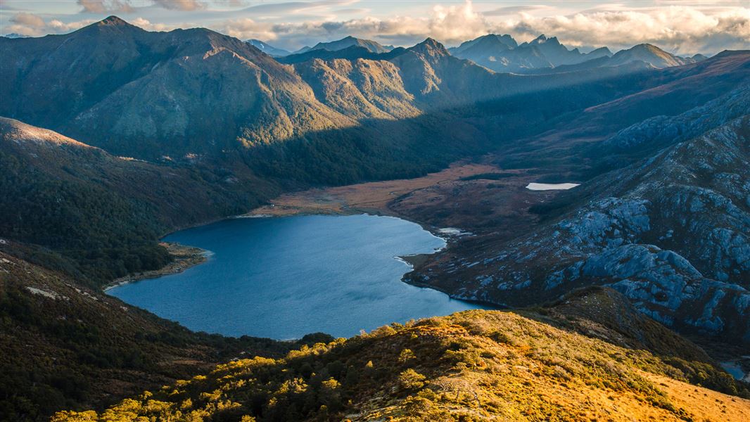
This guide covers the route linking the Aorere Valley to the Cobb reservoir via Boulder Lake, Adelaide Tarn, Lonely Lake and the Cobb Valley. The route is described west to east (from the Aorere Valley end).
It is only suitable for trampers with a high degree of off-track and navigational experience, as well as very good fitness. Allow at least 4 and a half days, plus a reserve day if possible for any weather delays. Streams and rivers are not bridged and many parts of the route are highly exposed to adverse weather.
While both ends of the route use DOC tracks, the middle section from Boulder Lake through to Fenella Hut is untracked. Through this section, you are generally following an informal route marked with irregular rock cairns in steep and rocky country. Before undertaking this trip you should assess your party’s skill levels and read trip reports online, to make sure you have the experience and skills for the terrain.
This area is a hotspot for Search and Rescue operations – carry a distress beacon.
Road end to Boulder Lake Hut (8-10 hr)
The track starts just across the paddock behind the intentions shelter. The first 6 km to Lookout Knob is a gradual climb through regenerating low forest, before a transition to mature forest and then limestone-capped country. There are some challenging limestone slots to cross here, with steep drops – go slowly and take care to avoid falling.
The track then continues to climb through beech and manuka forest, passing Beathams Clearing. There is sometimes a water source here. The track then sildes along the left side of the Pulpit and emerges at the open Cow Saddle.
From Cow Saddle, the track is fully exposed to the weather conditions and follows a poled route to Boulder Lake. It sidles around to the right, to a point beside a small outcrop on the skyline ridge. Continue to sidle under the bluffs of Brown Cow, crossing the top of a steep shingle scree slope and then descend on a tussock spur to the lake. This sidle and particularly the scree crossing is an avalanche hazard in winter and a fall risk at all times. Once at the lake, continue around the eastern edge of the lake to Boulder Lake Hut.
Water is an issue on this track. There is a small stream 30 min from the start, then no reliable water sources until you reach Boulder Lake. Make sure to carry enough for your needs, we recommend 2-3 L per person. Many parties also underestimate the time required for this section, so start early and/or carry camping gear to stay overnight.
Side trip to dam wall and waterfall, the source of the Boulder River
From Kiwi Creek a 30 minute (one way) side trip takes you to view the remains of the dam wall, built by gold miners across the lake outlet stream. The water from the lake was led by a long series of flumes and aqueducts to sluice gold claims on the Quartz Range goldfields, 6 km away. A view of the spectacular 65 m waterfall, the beginning of Boulder River, can be seen by climbing to an obvious vantage point further to the west of the wall remains.
Boulder Lake Hut to Adelaide Tarn Hut (5-6 hr)
This section of the route requires a high degree of off-track experience and fitness. It is not for the inexperienced and is very exposed to harsh weather conditions. Streams and rivers are not bridged. Carry gas or liquid fuel cookers as wood fuel is unavailable at Adelaide Tarn and Lonely Lake huts, and a tent as these huts have limited sleeping space.
From Boulder Lake Hut continue up the valley to pick up rock cairns that lead up the only tussock spur to Green Saddle. There is an optional sidle to the left into Green Saddle, starting above the bush edge in this spur. Continue to the next small saddle before and under point 1450 metres. Here two large rock cairns on a quartz outcrop mark the first two sidles on the Anatoki side of this main ridge to the Needles Eye.
The first sidle is on a cairned animal track passing under point 1450 metres, then it gains and follows the stunted bush ridge to the second sidle under points 1411 metres and 1488 metres. Descend and sidle through the bush on a marked animal track to pick up cairns across a tussock face under the obvious rock ribs. This then leads to the top of the first finger of bush in a narrow gut under the Needles Eye. Climb this flax-filled gut to the Needles Eye (saddle). From the Eye descend directly onto a short tussock spur to an obvious track and terrace that leads towards Adelaide Tarn and hut. Do not attempt to sidle from the Eye around the Needle to the hut - it is steep and bluffed.
Adelaide Tarn Hut to Anatoki Forks Hut (5-6hr)
If going from Boulder Lake to Anatoki Forks Hut (standard hut, 6 bunks) directly, follow the cairned route from the Needles Eye, sidling down towards the saddle leading to Yuletide. This route passes under bluff and rocky sections on the northern slopes of the Needle, reaching the saddle, and then climbs up and over Yuletide Peak.
From Adelaide Tarn retrace the route back to the Needles Eye and sidle around the north side of the Needle. The route over Yuletide Peak is cairned. The route goes over Yuletide Peak then follows the long, rather broken ridge towards the Anatoki Forks. A marked track is reached and descends steeply through silver and mountain beech forest to the south branch of the Anatoki River. This river can be extremely difficult to cross in flood and it may be necessary to go up river to cross or wait it out. Once across the river the track meets the Anatoki Track. Turn left and follow the track to the Anatoki Forks Hut.
Lonely Lake Hut to Adelaide Tarn Hut (8-10 hr)
All Grid References refer to map BP23 Gouland Downs.
From the hut head north up a small gully to a saddle north-west of the Drunken Sailors. From here sidle eastwards on the northern side of the Drunken Sailors to an open spur. Follow this spur north-eastwards to Grid Reference 636 642. From here follow the long ridge that drops to the north-east into the Anatoki River, arriving at Grid Reference 640 652.
From here, head up the Anatoki River to the forks at Grid Reference 626 665. Take the west branch of the river and follow it upstream until below the bluffs north-east of the Dragons Teeth. From here, climb northwards up a steep gut to emerge on the saddle east of Mt Douglas, Grid Reference 614 672. Proceed north-east down into the basin to Adelaide Tarn and Adelaide Tarn Hut.
Adelaide Tarn Hut to Lonely Lake Hut (8-10 hr)
All Grid References refer to map BP23 Gouland Downs.
From Adelaide Tarn climb up behind the hut to the saddle directly east of Mt Douglas, Grid Reference 614 672. A steep gut marked with a rock cairn gives access to the headwaters of the Anatoki River. Once in the bush at the base of this gut, head further southward until below the bluffs under the Dragons Teeth. From here veer eastwards following the course of the stream which becomes the Anatoki River.
Follow the Anatoki River downstream to Grid Reference 640 652. From this point climb the ridge to the south-west and emerge on an open ridge east of the Drunken Sailors. From here sidle on the north side of the Drunken sailors to pick up the cairns leading into a saddle and down to Lonely Lake Hut.
Lonely Lake Hut to Fenella Hut (6-8 hr)
From Lonely Lake Hut follow the non-maintained track that sidles up through bush onto the Douglas Range and the open ridge line. Follow the ridge, with the occasional optional sidle on animal tracks. Sidle across the scree under Kakapo Peak and regain the ridge, and then follow the cairned route that sidles below point 1550 metres and Waingaro Peak to reach a bushed spur. Continue down a well-marked track to Fenella Hut.
Note: The route from Lonely Lake to Waingaro Peak is cairned.
Fenella Hut to Trilobite Hut/roadend (4-5 hr)
From Fenella Hut the track drops down a series of glacier worn rocky steps and after about 20 minutes you reach Cobb Hut.
A short side walk takes you to Lake Cobb and Round Lake above it. From Cobb Hut continue down the valley, passing Chaffeys Hut (basic hut, 3 bunks) and finishing at Trilobite Hut (standard hut, 12 bunks) and the roadend.
Turn off Aorere Valley Road at Bainham, 18 km from Collingwood. Follow the signs along James Road to the Aorere River bridge. Cross the bridge, and the track start and intentions shelter are a further 200 m along the road.
Ensure you complete your intentions in the intentions shelter and subsequent hut books. These will be checked in case of an emergency.
Experience required
The Douglas Range Route is suitable only for experienced trampers who have a high level of backcountry experience including navigation and map reading skills. Most of this route is unmarked and follows natural features such as rivers, saddles and ridges. Streams and rivers are not bridged and the route has many exposed sections.
Trampers should be well equipped, fit and self-sufficient. Poor visibility due to mist on the tops can make route finding and orientation difficult. The terrain is often rough. Rain and flooded streams can alter your plans and freezing conditions can occur at any time of year.
Maps required
Trampers will need to carry and know how to use a topographic map. The relevant 1:50,000 Topo50 maps are:
- BP24 Takaka
- BP23 Gouland Downs
We also advise you to carry a GPS and an emergency beacon (hire outlets are listed on www.beacons.org.nz).
What to expect
- Wasps are a known hazard and are particularly common from December until April. Carry antihistamine if you are allergic to their stings.
- Avalanches occur in winter – make sure you have the skills and equipment needed. There are avalanche hazards across the exposed tops, with a particularly notable section of avalanche risk near the bluffs of Brown Cow.
- Water - it is recommended you boil, filter or treat drinking water collected in this area.
- Weather - check the weather forecast before you go. Kahurangi National park weather forecast – NIWA website
Stay safe when crossing rivers
If you plan to cross unbridged rivers, know how to cross safely and be prepared for if you cannot cross.
Do not cross if the river is flooded, you cannot find safe entry and exit points or are unsure it’s safe. Turn back or wait for the river to drop. If in doubt, stay out.
The Douglas Range Route includes spectacular views and passes through limestone-capped terrain, classic Kahurangi alpine ridges, tussock lands, beech and manuka forests, and lakes and rivers.
Highlights include a view of a spectacular 65 m waterfall on the first day of the route. This requires a small detour to the outlet of Boulder Lake where the remains of an old gold mining dam can also be seen.
Trout fishing can be done in the Cobb River. Each angler must carry a fishing licence.
Hunting is available in the Douglas Range Route area. Each hunter must carry a permit.
Stay safe in the outdoors
- Choose the right trip for you. Learn about the route and make sure you have the skills for it.
- Understand the weather. Check weather forecasts.
- Pack warm clothes and extra food. Check gear lists.
- Share your plans and take ways to get help. Share directly or use the Outdoor Intentions form or Plan My Walk. Take a distress beacon.
- Take care of yourself and each other.
Whakatū/Nelson Visitor Centre | |
---|---|
Phone | +64 3 546 9339 |
nelsonvc@doc.govt.nz | |
Address | Millers Acre/Taha o te Awa 1/37 Halifax Street Nelson 7010 |
Hours | Visitor centre hours and services |