May to October:
- Additional hazards on all routes to Angelus Hut including snow, ice, avalanche risk and sub-zero temperatures.
- Hut facilities reduced – water and firewood may not be available at the hut.
Bookings are required for Angelus Hut (and nearby campsite) all year round.
Check conditions in the 'Know Before You Go' section below before you travel.
You must be fit enough to walk for 2–3 days, up to 12.2 km for 6 hours per day and climb to 1,800 m. You must be comfortable on rough terrain and without a fear of heights.
Walking options
There are four options to reach Angelus Hut:
Pinchgut Track, Robert Ridge Route
The most popular route in fine weather. Expect ice and snow during winter and spring. A very exposed ridge subject to high wind and poor visibility. There is no water along the track/route.
Speargrass Track, Speargrass Creek Route
This route is often used to exit Rotomaninitua/Lake Angelus in bad weather. There are unbridged stream crossings, and the route is marked with poles for navigation. There may be muddy sections below the bush edge.
Travers – Cascade Track/Route
Expect ice and snow during winter and spring. Above the bush edge route navigation is via poles and cairns. From May to November, the bridge over the Hukere Stream is removed due to avalanche risk. After rain and during snow melt, crossing the river can be difficult – take extreme care.
Mt Cedric Track/Route
This route would only be used by trampers accessing Angelus Hut via the Travers–Sabine Circuit. There is no water along the track/route. Expect ice and snow during winter and spring. The track is a steep climb to the bush edge. Route navigation above the bush edge is via poles and cairns. A very exposed ridge, subject to high winds and poor visibility.
Understand if you are ready for this tramp
Watch the NZ Mountain Safety Council’s walk-through video which takes you through how to prepare for this track. Including facilities, key decision points, hazards and typical conditions for the area.
Angelus Hut tracks and routes November to April
What to take
Pack a range of equipment for warm, cold, windy or wet conditions.
Overnight and multi-day tramp gear list.
Take a day’s spare food in case of delay due to weather conditions.
Weather
Hospitable and welcoming on a fine day, the Angelus basin and the alpine access routes are prone to sudden weather changes bringing freezing winds and snow at any time of the year.
Even small streams are dangerous in flood. Winter conditions or bad weather could slow or stop your progress to or from the hut. A fall onto hard or icy snow could be lethal. Snow avalanches are possible.
Sandflies and wasps
Sandflies are tiny black insects that cause itchy bites. Cover up and use insect repellent.
There are many wasps in the area, especially from January to April. Consider carrying an antihistamine product and, if you are allergic to stings, ensure you bring your medication.
Giardia
Giardia has not been found in waters along the track but its presence cannot be dismissed. To avoid giardia, water should be boiled, chemically treated or filtered.
Angelus Hut tracks and routes May to October
You need special skills and preparation and excellent fitness to complete the route to Angelus Hut in winter (May to October). There are increased risks from snow, ice, avalanche terrain and sub-zero temperatures. The trip to the hut can take up to 9 hours with limited daylight.
Track standard: Tramping Track, Route
Track surface: Track is covered in snow and is very icy in sections above the bushline.
Suitable for: People with alpine skills, equipment and experience. You must:
- know how to navigate if cloud or snow covers the marker poles and you cannot see them
- know where avalanches are a risk and be able to rescue someone if an avalanche occurs
- have the equipment and skills to prevent a slide on icy terrain
- have the clothing for sub-zero temperatures and be able to survive if the weather gets worse
- be prepared to spend a night in the open or turn back early if your progress is too slow.
Prepare for a challenging tramp
Allow up to 9 hours in heavy snow conditions to complete the Robert Ridge Route or Travers-Cascade Route via Lakehead Hut or Coldwater Hut, and up to 9 hours on the Mt Cedric Track via Sabine Hut.
There are between 9 and 11 hours of daylight in winter, so leave early enough to complete the trip before it gets dark. Always take a head torch.
The snow depth will increase and weather conditions may worsen as you get deeper into the mountains. Be prepared to turn back early if conditions are no longer safe or your progress is too slow.
In whiteout conditions, the tracks can be extremely difficult to find.
Dress for cold, windy and icy conditions
On a calm day, Angelus Hut (1650 m) is at least 6oC colder than at the Rotoiti/Nelson Lakes Visitor Centre. Subtract another 2oC (35.6oF) for every 10 km/h of wind. Subtract another 6.5oC (43.7oF) for every 1,000 m ascent.
The routes to Angelus Hut are at altitude in an alpine environment. The weather can be highly changebale - within minutes, the weather can go from clear skies to whiteout conditions. The cold can be intense. Hypothermia is a real risk and can be fatal – recognise the symptoms. People may shiver, be clumsy, confused, have slurred speech, and deny they have a problem).
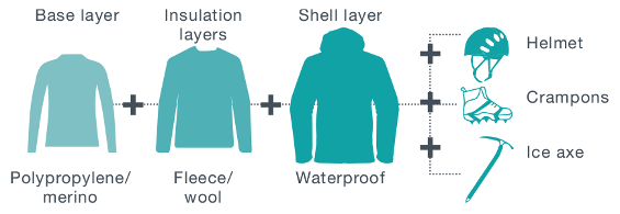
Layer your clothes to trap warm air in and keep cold wind out. Start with a base layer of polypropylene/merino, add an insulation layer of fleece/wool and finish with a waterproof shell layer.

Expect ice on the track from May to December. Crampons and an ice axe are essential, as is the competency using them. 38% of tramping injuries are from slipping.
Be avalanche alert
Avalanches are a hazard. All tracks/routes to Angelus Hut during winter are subject to avalanches. Carefully consider the the class of avalanche terrain you're getting into:
Avalanches occur in the park every year normally between June and October but sometimes as late as December. Even if you can't see snow from the track, there may be enough out of sight on the upper slopes to form an avalanche that could reach the track.
What to take
Overnight and multi-day tramping gear list
And takes these essentials:
- Plenty of drinking water - there is no drinking water along Robert Ridge Route.
- Gas cooker, fire starter, utensils, sleeping bag, and toilet paper for Angelus Hut.
- Waterproof jacket and pants, hat, gloves, sunscreen, and warm, layered clothing.
- Sturdy tramping or mountaineering boots.
- Crampons and ice axe.
- Avalanche transceiver, avalanche probe and snow shovel.
- Personal locator beacon (PLB), head torch and spare batteries – there is very limited mobile reception on the route, and only on Robert Ridge.
- Map, compass and/or GPS.
Make a plan
Talk with someone at the Rotoiti/Nelson Lakes Visitor Centre who knows the current conditions.
Check the latest:
Know the route – deep snow and whiteout conditions can hide track markers.
About the hut in winter
- You may have to dig your way into the hut. Snow drifts frequently block the entrance.
- There is no water inside the hut. Plumbing is disconnected to avoid freezing and cracking of pipes.
- The hut may be cold. Firewood may not be available.

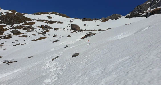
Poles covered in snow

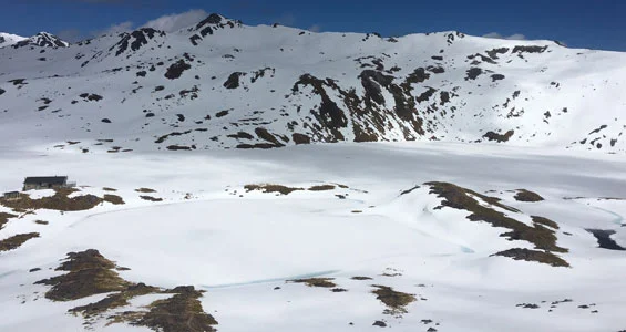
Rotomaninitua/Lake Angelus and hut in winter
Check the weather and current conditions before you go
Check the weather and the Mountain Safety Council's camera to help you plan and prepare.
Weather forecast
Angelus Hut weather forecast - NIWA website
Webcam for current conditions
The Mountain Safety Council have installed a webcam that faces southwest of the Angelus Basin. It provides data for avalanche forecasts and offers trampers a view of current conditions.
The image below is the latest available image from the webcam. The time it was taken is shown in the lower left corner:

Be aware there may be times when images from the webcam are unavailable or inconsistent due to the remote location.
View previous images on the Mountain Safety Council's website.
Stay safe in the outdoors
- Choose the right trip for you. Learn about the route and make sure you have the skills for it.
- Understand the weather. Check weather forecasts.
- Pack warm clothes and extra food. Check gear lists.
- Share your plans and take ways to get help. Leave your intentions with a trusted contact and take a distress beacon.
- Take care of yourself and each other.
Nelson Lakes National Park Visitor Centre
| Phone: | +64 3 521 1806 |
| Email: | nelsonlakesvc@doc.govt.nz |
| Address: | View Road St Arnaud 7072 |
| Hours: | Visitor centre hours and services |
Whakatū/Nelson Visitor Centre
| Phone: | +64 3 546 9339 |
| Email: | nelsonvc@doc.govt.nz |
| Address: | Millers Acre/Taha o te Awa 1/37 Halifax Street Nelson 7010 |
| Hours: | Visitor centre hours and services |
